File:ISS036-E-16096 - View of Cuba--gulf of Batabano, east limit.jpg

Size of this preview: 800 × 532 pixels. Other resolutions: 320 × 213 pixels | 640 × 426 pixels | 1,024 × 681 pixels | 1,280 × 852 pixels | 2,560 × 1,703 pixels | 4,256 × 2,832 pixels.
Original file (4,256 × 2,832 pixels, file size: 640 KB, MIME type: image/jpeg)
Captions
Captions
View of Cuba taken during ISS Expedition 36
Summary edit
| Description |
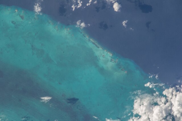
English: View of Cuba taken during ISS Expedition 36. Tiny reefs located (according to the coordinates given here) in the gulf of Batabano, about 15 km north-east of the west end of Cayo Largo (Cayo Largo del Sur, Canarreos archipelago) They are aligned(south) with the east side of cayos Blancos del Sur (fr:the archipel, not the island formerly called "cayo Blanco del Sur" and renamed "Ernst Thälmann Island" which is in the middle of that archipelago). These reefs do not show on any of the usual maps (openstreetmap, google/maps and some more); nor do they show on google/maps satellite view. The only usual map that shows them is the satellite view (not the map) in Mapcarta - this site does not allow for exact pointing link, here is cayo Largo del Sur : find the east cape, go 15 km east and up a bit. However tiny they may be, the change of colour of the sea on each side of them shows that they mark the limit of the gulf of Batabano. Upper right corner darker blue is the "tail" of gulf of Cazones. |
| Date | |
| Source | JSC Gateway to Astronaut Photography of Earth |
| Author | Earth Science and Remote Sensing Unit, Lyndon B. Johnson Space Center |
| Mission | ISS036 |
| Roll | E |
| Frame | 16096 |
| Geographic area | Cuba |
| Features | PUBLIC INPUTS |
| Cloud percentage | 10% |
| Altitude | 227 nautical miles (420 km) |
| Look angle | HO |
| Look direction | NE |
| Sun Azimuth | 254° |
| Sun Elevation | -47° |
| Camera | Nikon D3S Electronic Still Camera |
| Focal length | 800 mm |
| Camera location | | View this and other nearby images on: OpenStreetMap |
|---|
| Object location | | View this and other nearby images on: OpenStreetMap |
|---|
This image or video was catalogued by Johnson Space Center of the United States National Aeronautics and Space Administration (NASA) under Photo ID: ISS036-E-16096. This tag does not indicate the copyright status of the attached work. A normal copyright tag is still required. See Commons:Licensing. Other languages:
|
Licensing edit
| This file is in the public domain in the United States because it was solely created by NASA. NASA copyright policy states that "NASA material is not protected by copyright unless noted". (See Template:PD-USGov, NASA copyright policy page or JPL Image Use Policy.) | ||
 |
Warnings:
|
File history
Click on a date/time to view the file as it appeared at that time.
| Date/Time | Thumbnail | Dimensions | User | Comment | |
|---|---|---|---|---|---|
| current | 19:04, 18 June 2022 | | 4,256 × 2,832 (640 KB) | AskeBot (talk | contribs) |
You cannot overwrite this file.
File usage on Commons
The following page uses this file:
- File:ISS036-E-16096 - View of Cuba.jpg (file redirect)