File:Ice in the Kane Basin, Greenland (MODIS 2019-06-03).jpg

Size of this preview: 800 × 562 pixels. Other resolutions: 320 × 225 pixels | 640 × 450 pixels | 1,024 × 720 pixels | 1,280 × 900 pixels | 2,560 × 1,800 pixels | 4,853 × 3,412 pixels.
Original file (4,853 × 3,412 pixels, file size: 4.43 MB, MIME type: image/jpeg)
Captions
Captions
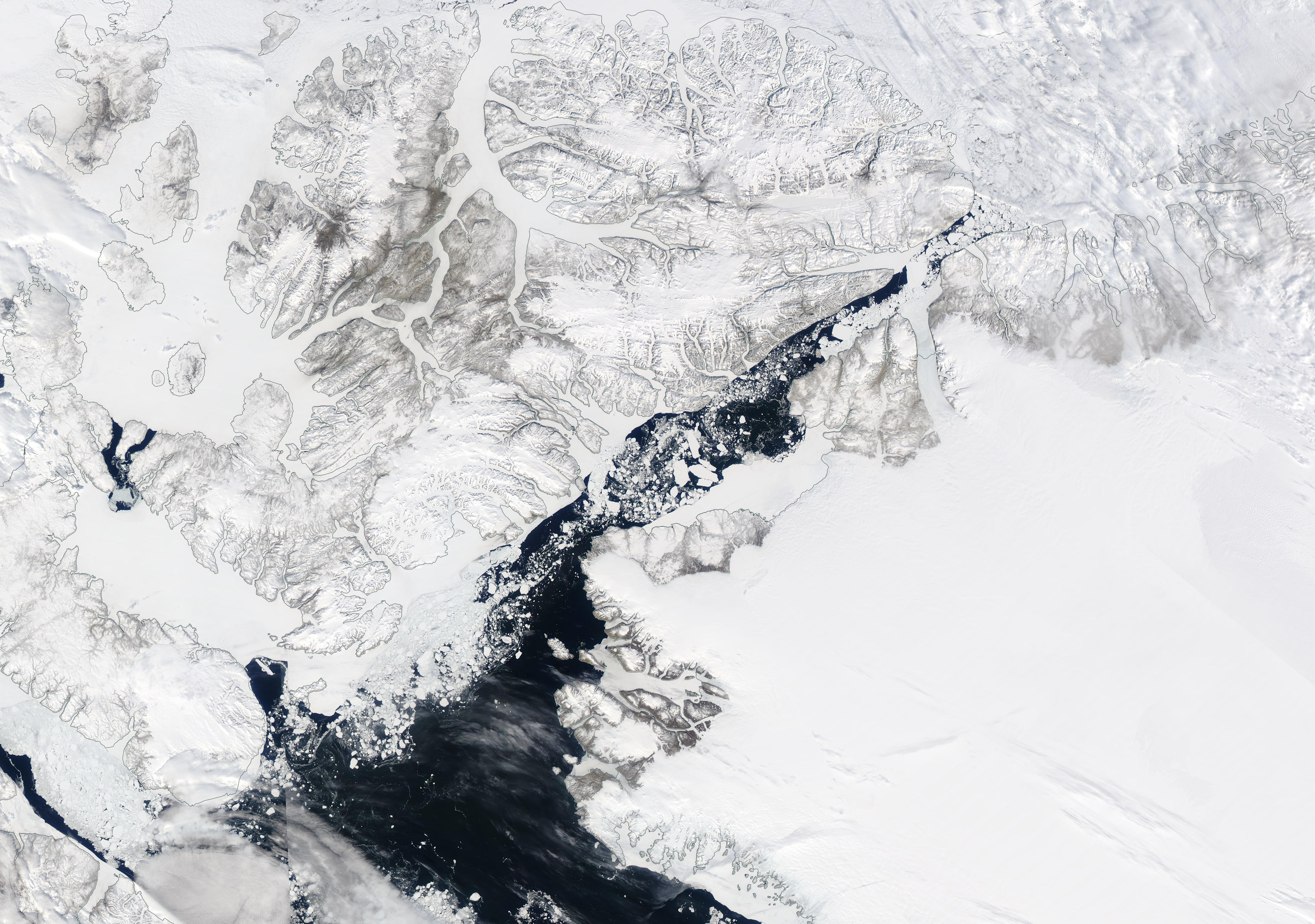
On May 30, 2019, the Moderate Resolution Imaging Spectroradiometer (MODIS) on board NASA’s Aqua satellite acquired a true-color image centered on ice in the Kane Strait.
Summary edit
.jpg&action=edit§ion=1)
| Description |
English: The Kane Basin extends about 110 miles (177 km) to form a channel between Greenland and Canada’s Ellesmere Island. The Basin is relatively shallow, with depths of about 525 feet (160 meters) and makes up a part of the longer Nares Strait. In the frigid weather of winter, most of the Kane Basin freezes solid, especially in the north, creating a northern bridge that allows transportation between Canada and Greenland. The thick ice also keeps the northern pack ice over the Arctic Ocean from flowing southward. This gate-like function a role in keeping the waters of Baffin Bay (south of the Kane Basin) open and ice-free year-round. This ice-free area is called the North Water Polynya, and is one of Earth’s most productive ecosystems, providing critical habitat for a wide variety of species including narwhal, polar bear, walrus, seal, an abundance of fish, and birds. The health North Water Polynya depends on consistent ice conditions to the north. As the northern ice arch thins in a warming climate, pack ice can intrude on the polynya, which may have consequences for the flora, fauna, and local human communities that depend on the productivity of the open water.
On May 30, 2019, the Moderate Resolution Imaging Spectroradiometer (MODIS) on board NASA’s Aqua satellite acquired a true-color image centered on ice in the Kane Strait. Although only the end of May, the waters of the Kane Basin are relatively open, with significant ice melt almost to the Arctic Ocean (north). Large icebergs and ice of a variety of sizes float along the blue water of the Basin. Along the shores of Greenland, a number of glaciers can be seen. The largest, the Humboldt Glacier, covers a wide expanse of land and the large tongue covers much of the water along the east coast of the Kane Basin. The front of the Humboldt Glacier is about 68 miles (110 km) wide. In the image, this glacier appears as an unbroken area not much different than the surrounding ice and snow between two rocky areas only lightly covered with snow. The Petermann Glacier sits just north of the Humboldt. It is much narrower and appears distinctly different in shape and texture than the edge of the nearby ice sheet. The Petermann Glacier heads north-northeast, with the floating tongue nearly reaching the Arctic Ocean. |
||
| Date | Taken on 30 May 2019 | ||
| Source |
Ice in the Kane Basin, Greenland (direct link)
|
||
| Author | MODIS Land Rapid Response Team, NASA GSFC |
| This media is a product of the Aqua mission Credit and attribution belongs to the mission team, if not already specified in the "author" row |
Licensing edit
.jpg&action=edit§ion=2)
| This file is in the public domain in the United States because it was solely created by NASA. NASA copyright policy states that "NASA material is not protected by copyright unless noted". (See Template:PD-USGov, NASA copyright policy page or JPL Image Use Policy.) | ||
 |
Warnings:
|
File history
Click on a date/time to view the file as it appeared at that time.
| Date/Time | Thumbnail | Dimensions | User | Comment | |
|---|---|---|---|---|---|
| current | 03:18, 17 February 2024 | | 4,853 × 3,412 (4.43 MB) | OptimusPrimeBot (talk | contribs) | #Spacemedia - Upload of http://modis.gsfc.nasa.gov/gallery/images/image06032019_250m.jpg via Commons:Spacemedia |
You cannot overwrite this file.
File usage on Commons
There are no pages that use this file.
.jpg&oldid=852756423)