File:Ihnc-12.jpg

Size of this preview: 778 × 599 pixels. Other resolutions: 312 × 240 pixels | 623 × 480 pixels | 888 × 684 pixels.
Original file (888 × 684 pixels, file size: 103 KB, MIME type: image/jpeg)
Captions
Captions
Add a one-line explanation of what this file represents
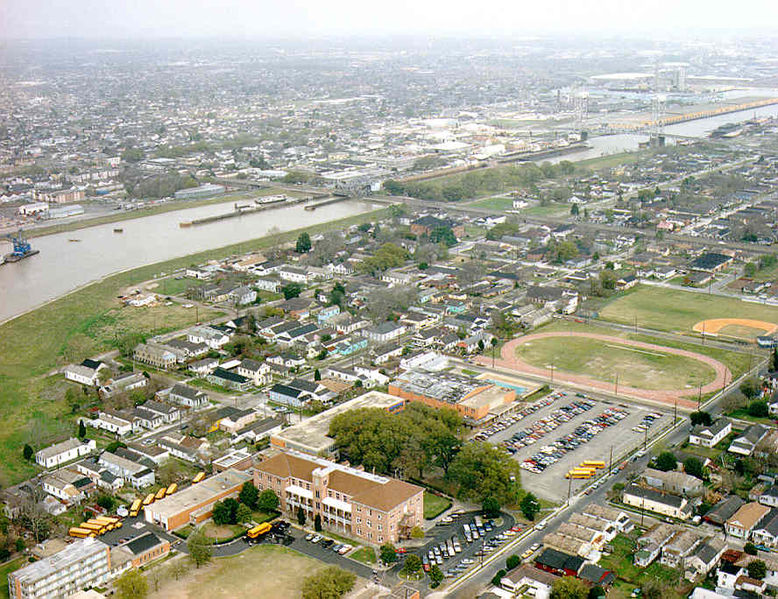
New Orleans: An aerial photograph of Inner Harbor Navigation Canal or Industrial Canal running diagonally through center of photo. Undated pre-Katrina U.S. Army Corps of Engineers photo.
Part of the Lower 9th Ward visible to right/below Canal. Holy Cross School campus at center bottom. St. Claude Avenue Bridge over the Canal and the Canal Lock at center; Claiborne Avenue Bridge over the Canal further to the right.
Sourced from [1]
This image or file is a work of a U.S. Army Corps of Engineers soldier or employee, taken or made as part of that person's official duties. As a work of the U.S. federal government, the image is in the public domain.
|
File history
Click on a date/time to view the file as it appeared at that time.
| Date/Time | Thumbnail | Dimensions | User | Comment | |
|---|---|---|---|---|---|
| current | 13:25, 11 March 2007 | | 888 × 684 (103 KB) | Infrogmation (talk | contribs) | New Orleans: An aerial photograph of Inner Harbor Navigation Canal or Industrial Canal running diagonally through center of photo. Undated pre-Katrina U.S. Army Corps of Engineers photo. Part of the Lower 9th Ward visible to right/below Canal. Holy |
You cannot overwrite this file.
File usage on Commons
There are no pages that use this file.