File:Ile de France departments 1968 evolution map-de.svg

Size of this PNG preview of this SVG file: 480 × 600 pixels. Other resolutions: 192 × 240 pixels | 384 × 480 pixels | 614 × 768 pixels | 819 × 1,024 pixels | 1,638 × 2,048 pixels | 512 × 640 pixels.
Original file (SVG file, nominally 512 × 640 pixels, file size: 362 KB)
Captions
Captions
Add a one-line explanation of what this file represents
Summary
edit
| Description |
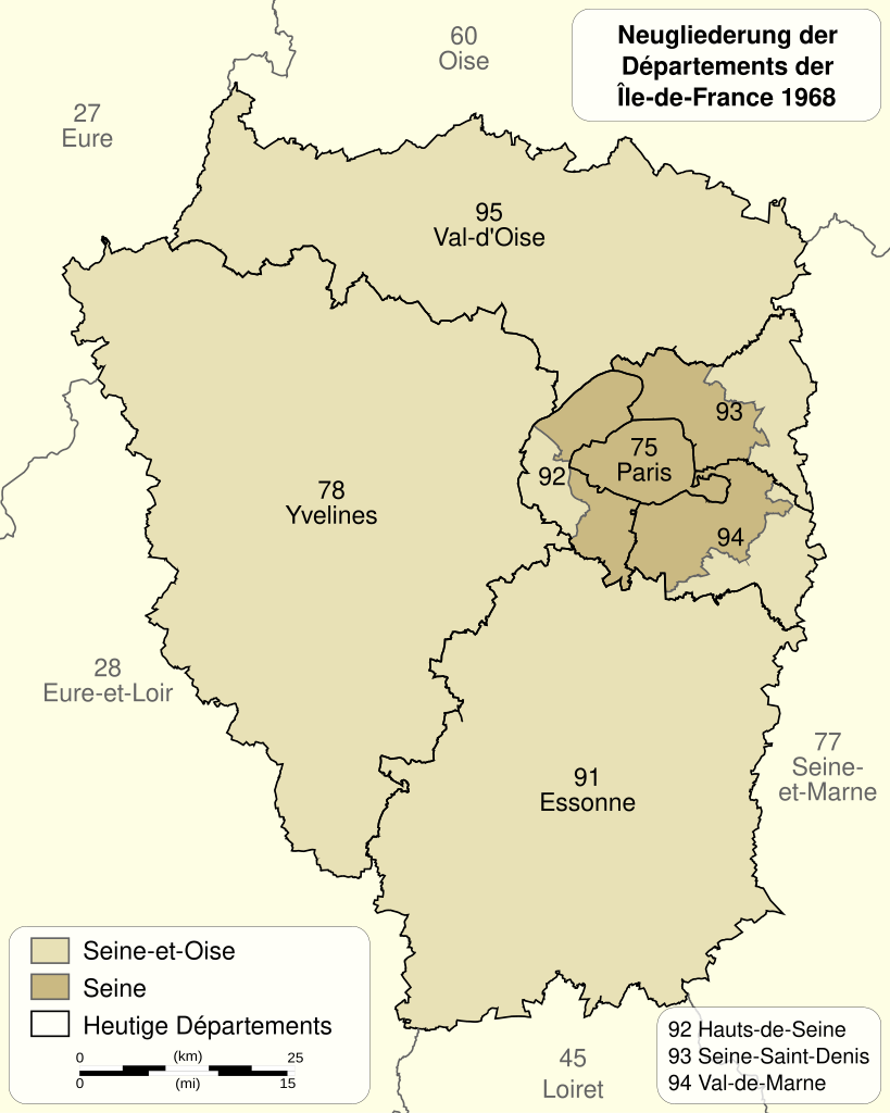
Deutsch: Neugliederung der Départements der Île-de-France 1964-1968. English: Changes of the boundaries of departments in Île-de-France in 1964-1968. Français : Évolution territoriale des départements de l'Île-de-France en 1964-1968. |
| Date | (UTC) |
| Source |
This file was derived from: Ile de France departments 1968 evolution map-fr.svg:  |
| Author |
|
| This is a retouched picture, which means that it has been digitally altered from its original version. Modifications: traduction allemand / deutsche Übersetzung / German translation. The original can be viewed here: Ile de France departments 1968 evolution map-fr.svg:
|
Licensing
edit
I, the copyright holder of this work, hereby publish it under the following licenses:
This file is licensed under the Creative Commons Attribution-Share Alike 3.0 Unported, 2.5 Generic, 2.0 Generic and 1.0 Generic license.
- You are free:
- to share – to copy, distribute and transmit the work
- to remix – to adapt the work
- Under the following conditions:
- attribution – You must give appropriate credit, provide a link to the license, and indicate if changes were made. You may do so in any reasonable manner, but not in any way that suggests the licensor endorses you or your use.
- share alike – If you remix, transform, or build upon the material, you must distribute your contributions under the same or compatible license as the original.
| Copyleft: This work of art is free; you can redistribute it and/or modify it according to terms of the Free Art License. You will find a specimen of this license on the Copyleft Attitude site as well as on other sites. |
You may select the license of your choice.
Original upload log
edit
This image is a derivative work of the following images:
- File:Ile_de_France_departments_1968_evolution_map-fr.svg licensed with Cc-by-sa-3.0,2.5,2.0,1.0, FAL
- 2011-12-06T20:21:45Z Sémhur 512x640 (375955 Bytes) == {{int:filedesc}} == {{Information |Description={{Multilingual description |en= Changes of the boundaries of departments in [[:en:Île-de-France (region)|Île-de-France]] in 1964-1968. |fr= Évolution territoriale des dépa
Uploaded with derivativeFX
File history
Click on a date/time to view the file as it appeared at that time.
| Date/Time | Thumbnail | Dimensions | User | Comment | |
|---|---|---|---|---|---|
| current | 17:48, 1 September 2012 | | 512 × 640 (362 KB) | Furfur (talk | contribs) | == {{int:filedesc}} == {{Information |Description={{Multilingual description |de= Neugliederung der Départements der Île-de-France 1964-1968.|fr= Évolution territoriale des départements de l'[[:fr:Île-de-France|Île-de-Franc... |
You cannot overwrite this file.
File usage on Commons
There are no pages that use this file.
File usage on other wikis
The following other wikis use this file:
- Usage on de.wikipedia.org
- Usage on el.wikipedia.org
- Usage on lb.wikipedia.org