File:Independent State Of Croatia 1943 (East) Locator Map.png
No higher resolution available.
Independent_State_Of_Croatia_1943_(East)_Locator_Map.png (295 × 424 pixels, file size: 30 KB, MIME type: image/png)
Captions
Captions
Add a one-line explanation of what this file represents
Summary edit
_Locator_Map.png&action=edit§ion=1)
| Description |
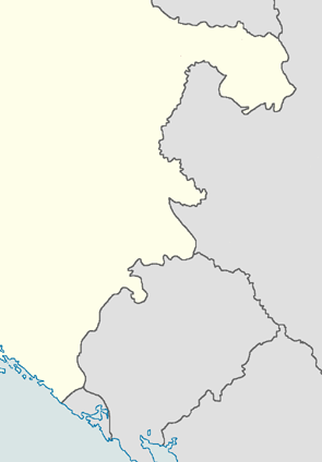
English: Shows the eastern portion of the Independent State of Croatia with borders 1943-1945 |
| Date | |
| Source | http://en.wikipedia.org/wiki/File:Independent_State_Of_Croatia_1943_Locator_Map.png |
| Author | User:XrysD |
Licensing edit
_Locator_Map.png&action=edit§ion=2)
This file is licensed under the Creative Commons Attribution-Share Alike 3.0 Unported license.
- You are free:
- to share – to copy, distribute and transmit the work
- to remix – to adapt the work
- Under the following conditions:
- attribution – You must give appropriate credit, provide a link to the license, and indicate if changes were made. You may do so in any reasonable manner, but not in any way that suggests the licensor endorses you or your use.
- share alike – If you remix, transform, or build upon the material, you must distribute your contributions under the same or compatible license as the original.
File history
Click on a date/time to view the file as it appeared at that time.
| Date/Time | Thumbnail | Dimensions | User | Comment | |
|---|---|---|---|---|---|
| current | 01:47, 8 January 2013 | | 295 × 424 (30 KB) | Peacemaker67 (talk | contribs) | User created page with UploadWizard |
You cannot overwrite this file.
File usage on Commons
There are no pages that use this file.
File usage on other wikis
The following other wikis use this file:
- Usage on ar.wikipedia.org
- Usage on bs.wikipedia.org
- Usage on ceb.wikipedia.org
- Usage on en.wikipedia.org
- Usage on kn.wikipedia.org
- Usage on si.wikipedia.org
- Usage on sr.wikipedia.org
- Usage on tg.wikipedia.org
- Usage on tr.wikipedia.org
- Usage on uz.wikipedia.org
- Usage on war.wikipedia.org
_Locator_Map.png&oldid=796684473)