File:Indian Railway Network Coverage on OSM.png

Size of this preview: 600 × 600 pixels. Other resolutions: 240 × 240 pixels | 480 × 480 pixels | 795 × 795 pixels.
Original file (795 × 795 pixels, file size: 326 KB, MIME type: image/png)
Captions
Captions
Add a one-line explanation of what this file represents
Summary edit
| Description |
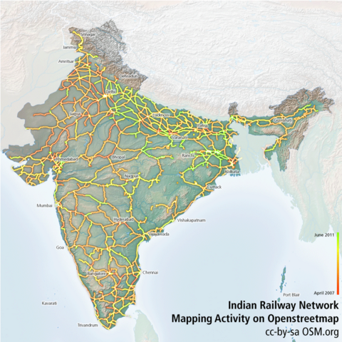
English: Coverage of the en:Indian Railway network from openstreetmap. See the discussion page for instructions on how to create this map |
| Source | Own work |
| Author | Planemad |
Licensing edit
| NATIONAL INSTITUTE OF DESIGN Bangalore Campus This is a work of a student or faculty from the National Institute of Design (India), 2024 |
CC-by-sa Arun Ganesh, National Institute of Design Bangalore
|
This file is licensed under the Creative Commons Attribution-Share Alike 3.0 Unported license.
- You are free:
- to share – to copy, distribute and transmit the work
- to remix – to adapt the work
- Under the following conditions:
- attribution – You must give appropriate credit, provide a link to the license, and indicate if changes were made. You may do so in any reasonable manner, but not in any way that suggests the licensor endorses you or your use.
- share alike – If you remix, transform, or build upon the material, you must distribute your contributions under the same or compatible license as the original.
File history
Click on a date/time to view the file as it appeared at that time.
| Date/Time | Thumbnail | Dimensions | User | Comment | |
|---|---|---|---|---|---|
| current | 09:59, 1 July 2011 | | 795 × 795 (326 KB) | Planemad (talk | contribs) | upd |
| 09:52, 1 July 2011 |  | 795 × 795 (326 KB) | Planemad (talk | contribs) | update june 2011 | |
| 05:46, 28 December 2010 |  | 795 × 795 (324 KB) | Planemad (talk | contribs) | dec update | |
| 04:22, 2 August 2010 |  | 795 × 795 (964 KB) | Planemad (talk | contribs) | july update | |
| 13:04, 10 July 2010 |  | 795 × 795 (959 KB) | Planemad (talk | contribs) | latest | |
| 17:10, 4 May 2010 |  | 795 × 795 (939 KB) | Planemad (talk | contribs) | update. rail tracing addiction :) | |
| 06:07, 4 May 2010 |  | 795 × 795 (938 KB) | Planemad (talk | contribs) | latest data | |
| 13:34, 3 May 2010 |  | 795 × 795 (937 KB) | Planemad (talk | contribs) | update with may data | |
| 16:18, 2 May 2010 |  | 795 × 798 (943 KB) | Planemad (talk | contribs) | add edit age | |
| 16:22, 30 April 2010 |  | 795 × 798 (892 KB) | Planemad (talk | contribs) | {{Information |Description={{en|1=Coverage of the en:Indian Railway network from openstreetmap}} |Source={{own}} |Author=Planemad |Date= |Permission= |other_versions= }} |
You cannot overwrite this file.
File usage on Commons
The following page uses this file: