File:Inini.png

Size of this preview: 523 × 600 pixels. Other resolutions: 209 × 240 pixels | 419 × 480 pixels | 670 × 768 pixels | 893 × 1,024 pixels | 1,884 × 2,160 pixels.
Original file (1,884 × 2,160 pixels, file size: 71 KB, MIME type: image/png)
Captions
Captions
Add a one-line explanation of what this file represents
Summary edit
| Description |
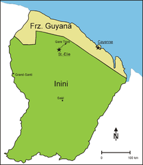
English: Division of French Guiana from 1930 to 1946 into a coastal strip, further called French Guiana, and the interior, administered as Territoire de l' Inini (Inini Territory)
Deutsch: Teilung Franz. Guyanas von 1930 bis 1946 in einen Küstenstreifen, der weiterhin Franz. Guyana genannt wurde und das Landesinnere, das unter dem Namen Inini verwaltet wurde. |
| Date | |
| Source | Own work, source for the northern boundary of Inini: http://www.waiapi-wayapi-teko.org/carte.htm |
| Author | Diorit |
Licensing edit
I, the copyright holder of this work, hereby publish it under the following license:
| This file is made available under the Creative Commons CC0 1.0 Universal Public Domain Dedication. | |
| The person who associated a work with this deed has dedicated the work to the public domain by waiving all of their rights to the work worldwide under copyright law, including all related and neighboring rights, to the extent allowed by law. You can copy, modify, distribute and perform the work, even for commercial purposes, all without asking permission.
|
File history
Click on a date/time to view the file as it appeared at that time.
| Date/Time | Thumbnail | Dimensions | User | Comment | |
|---|---|---|---|---|---|
| current | 12:42, 20 September 2012 | | 1,884 × 2,160 (71 KB) | Diorit (talk | contribs) | Place names larger, north arrow added |
| 12:34, 3 January 2011 |  | 1,884 × 2,160 (68 KB) | Diorit (talk | contribs) | {{Information |Description={{en|1=Division of French Guiana from 1930 to 1946 into a coastal strip, further called French Guiana, and the interior, administered as Territoire de l' Inini (Inini Territory)}} {{de|1=Teilung Franz. Guyanas von 1930 bis 1946 |
You cannot overwrite this file.
File usage on Commons
The following page uses this file:
File usage on other wikis
The following other wikis use this file: