File:Irene AMO 2005226 lrg.jpg

Original file (5,600 × 7,200 pixels, file size: 6.23 MB, MIME type: image/jpeg)
Captions
Captions
Summary edit
| Description |
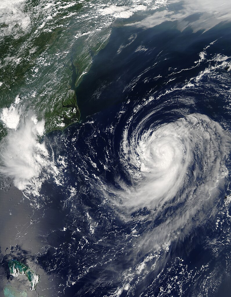
English: Irene was building towards a hurricane when the Moderate Resolution Imaging Spectroradiometer (MODIS) on NASA’s Aqua satellite captured this image at 2:20 p.m. U.S. Eastern Daylight Savings Time on August 14, 2005. By 11 p.m., Irene had become the third hurricane of the 2005 Atlantic hurricane season. The storm is moving northeast along the east coast of the United States and is not expected to make landfall, by National Hurricane Center predictions.
Along the top of the image, a pall of haze hugs the coast, blowing out over the Atlantic over the Chesapeake Bay. Such haze develops when hot, muggy weather caused by a high pressure system traps stagnant air. Emissions from cars and power plants build up, leading to hazy skies. The U.S. Environmental Protection Agency’s AirNow web site warned that air quality levels in the Mid-Atlantic states would be unhealthy for sensitive groups to unhealthy for all groups on August 13. Clearly, haze continued to affect the region on the following day. The large image provided above has a resolution of 500 meters per pixel. The MODIS Rapid Response Team provides the image in additional resolutions, including MODIS’ maximum resolution of 250 meters per pixel. |
| Date | |
| Source | http://earthobservatory.nasa.gov/NaturalHazards/quarterly.php?cat_id=10&y=2005&q=3 |
| Author | NASA; MODIS |
| Permission (Reusing this file) |
Public domain |
Licensing edit
| This file is in the public domain in the United States because it was solely created by NASA. NASA copyright policy states that "NASA material is not protected by copyright unless noted". (See Template:PD-USGov, NASA copyright policy page or JPL Image Use Policy.) | ||
 |
Warnings:
|
File history
Click on a date/time to view the file as it appeared at that time.
| Date/Time | Thumbnail | Dimensions | User | Comment | |
|---|---|---|---|---|---|
| current | 09:46, 31 July 2023 | | 5,600 × 7,200 (6.23 MB) | Nino Marakot (talk | contribs) | 250m resolution |
| 23:05, 29 December 2009 |  | 2,800 × 3,600 (2.46 MB) | Cyclonebiskit (talk | contribs) | {{Information |Description={{en|1=Irene was building towards a hurricane when the Moderate Resolution Imaging Spectroradiometer (MODIS) on NASA’s Aqua satellite captured this image at 2:20 p.m. U.S. Eastern Daylight Savings Time on August 14, 2005. By 1 |
You cannot overwrite this file.
File usage on Commons
There are no pages that use this file.
File usage on other wikis
The following other wikis use this file:
- Usage on es.wikipedia.org
- Usage on pt.wikipedia.org
- Usage on tr.wikipedia.org
- Usage on uk.wikipedia.org
- Usage on www.wikidata.org
- Usage on zh.wikipedia.org