File:Italia 1494-es.svg

Size of this PNG preview of this SVG file: 501 × 600 pixels. Other resolutions: 200 × 240 pixels | 401 × 480 pixels | 641 × 768 pixels | 855 × 1,024 pixels | 1,711 × 2,048 pixels | 3,481 × 4,167 pixels.
Original file (SVG file, nominally 3,481 × 4,167 pixels, file size: 1.39 MB)
Captions
Captions
Add a one-line explanation of what this file represents

Summary edit
| Description |
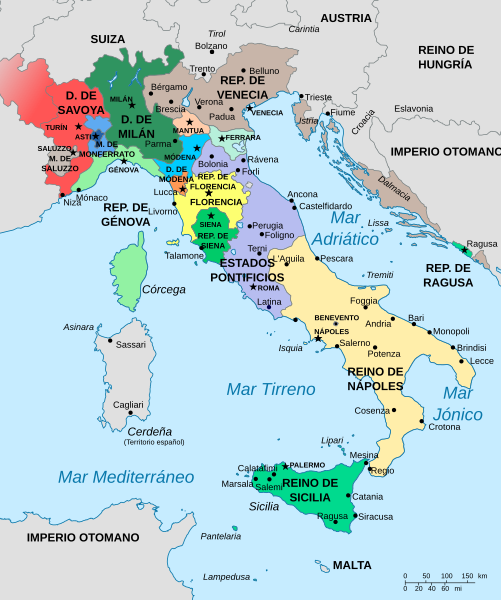
English: Map of Italy in 1494.
Español: Mapa de Italia en 1494.
Italiano: Mappa dell'Italia nel 1494.
Français : Carte de l'Italie vers 1494. |
| Date | |
| Source |
Own work based on: |
| Author | Milenioscuro |
| Other versions |
Other images (German map legends):
|


-ca.svg)
-it.svg)
-en.svg)
-pl.svg)
-mk.svg)


W3C-validity not checked.
Licensing edit
I, the copyright holder of this work, hereby publish it under the following license:
This file is licensed under the Creative Commons Attribution-Share Alike 3.0 Unported license.
- You are free:
- to share – to copy, distribute and transmit the work
- to remix – to adapt the work
- Under the following conditions:
- attribution – You must give appropriate credit, provide a link to the license, and indicate if changes were made. You may do so in any reasonable manner, but not in any way that suggests the licensor endorses you or your use.
- share alike – If you remix, transform, or build upon the material, you must distribute your contributions under the same or compatible license as the original.
File history
Click on a date/time to view the file as it appeared at that time.
| Date/Time | Thumbnail | Dimensions | User | Comment | |
|---|---|---|---|---|---|
| current | 08:01, 7 March 2017 | | 3,481 × 4,167 (1.39 MB) | Rowanwindwhistler (talk | contribs) | Fake text added |
| 10:36, 6 September 2016 |  | 3,481 × 4,167 (727 KB) | Rowanwindwhistler (talk | contribs) | The right file... | |
| 10:35, 6 September 2016 |  | 3,481 × 4,167 (1.25 MB) | Rowanwindwhistler (talk | contribs) | Pantelleria->Pantelaria Padova->Padua Crotone->Crotona Text is now real text (not a path) https://en.wikipedia.org/wiki/Wikipedia:WikiProject_Maps/Conventions | |
| 20:07, 17 March 2013 |  | 3,481 × 4,167 (1.25 MB) | Citypeek (talk | contribs) | Corrected file. Valid SVG now. | |
| 23:05, 5 July 2012 |  | 3,481 × 4,167 (988 KB) | Milenioscuro (talk | contribs) | correcciones en las fronteras por fuera de Italia | |
| 21:51, 5 July 2012 |  | 3,481 × 4,167 (940 KB) | Milenioscuro (talk | contribs) | {{Information |Description ={{en|1=Ma´pf Otaia}} |Source ={{own}} |Author =Shadowxfox |Date =2012-07-05 |Permission = |other_versions = }} Category:SVG maps of Italy [[Category:Territorial evol... |
You cannot overwrite this file.
File usage on Commons
The following 5 pages use this file:
File usage on other wikis
The following other wikis use this file:
- Usage on af.wikipedia.org
- Usage on ast.wikipedia.org
- Usage on ba.wikipedia.org
- Usage on ca.wikipedia.org
- Usage on co.wikipedia.org
- Usage on en.wikipedia.org
- Usage on eo.wikipedia.org
- Usage on es.wikipedia.org
- Casa de Saboya
- Historia de Italia
- Niza
- Saboya
- Renacimiento italiano
- Guerras italianas (1494-1559)
- Condado de Niza
- Ducado de Saboya
- Historia de Córcega
- Piero Soderini
- Guerra italiana de 1494-1498
- Reino de Italia (Sacro Imperio Romano Germánico)
- Juana de Montferrato
- Lorenzo II de Médici
- Guerra de Nápoles (1501-1504)
- Cuestión Adriática
- Italia española
- Historia territorial de Italia
- Innocenzo Cybo
- Bernardino Lonati
- Jean Bilhères de Lagraulas
- Usuario:LTB/Taller
- Usage on fr.wikipedia.org
- Usage on gl.wikipedia.org
- Usage on hu.wikipedia.org
- Usage on is.wikipedia.org
- Usage on nl.wikipedia.org
View more global usage of this file.