File:Izu islands.png
No higher resolution available.
Izu_islands.png (300 × 400 pixels, file size: 30 KB, MIME type: image/png)
Captions
Captions
Add a one-line explanation of what this file represents
Summary edit
| Description |
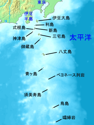
English: Low quality map of the Izu islands in Japanese. Created with Demis.
日本語: 伊豆諸島の地形図。データの出典はDemis。ファイルは投稿者作成。 |
| Date | |
| Source | Own work |
| Author | Tdk |
| Other versions |
|

Licensing edit
| This work has been released into the public domain by its author, Tdk at Japanese Wikipedia. This applies worldwide. In some countries this may not be legally possible; if so: Tdk grants anyone the right to use this work for any purpose, without any conditions, unless such conditions are required by law. |
Original upload log edit
| This file was moved from Japanese Wikipedia.
See below for original file information. | ||||||||||||||||||||||||||||
| ||||||||||||||||||||||||||||
|
| ||||||||||||||||||||||||||||
File history
Click on a date/time to view the file as it appeared at that time.
| Date/Time | Thumbnail | Dimensions | User | Comment | |
|---|---|---|---|---|---|
| current | 12:36, 28 October 2006 | | 300 × 400 (30 KB) | Onsf (talk | contribs) | PD IMAGE FORM JP-WIKI http://ja.wikipedia.org/wiki/%E7%94%BB%E5%83%8F:Izu_islands.png |
You cannot overwrite this file.
File usage on Commons
There are no pages that use this file.
File usage on other wikis
The following other wikis use this file: