File:Jade-weser-muendung map de.png

Size of this preview: 646 × 600 pixels. Other resolutions: 258 × 240 pixels | 517 × 480 pixels.
Original file (800 × 743 pixels, file size: 415 KB, MIME type: image/png)
Captions
Captions
Add a one-line explanation of what this file represents
Summary edit
| Description |
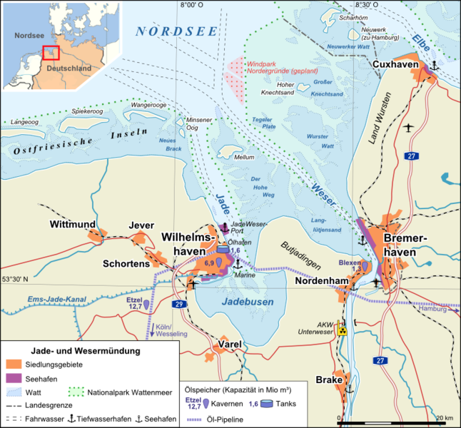
Deutsch: Übersichtskarte Jade- und Wesermündung |
|||
| Date | ||||
| Source |
Own work (Original text: self-made) |
|||
| Author | Alexrk | |||
| Other versions |
[]
|


Licensing edit
Alexrk, the copyright holder of this work, hereby publishes it under the following license:
This file is licensed under the Creative Commons Attribution-Share Alike 3.0 Unported license.
Attribution: Alexrk
- You are free:
- to share – to copy, distribute and transmit the work
- to remix – to adapt the work
- Under the following conditions:
- attribution – You must give appropriate credit, provide a link to the license, and indicate if changes were made. You may do so in any reasonable manner, but not in any way that suggests the licensor endorses you or your use.
- share alike – If you remix, transform, or build upon the material, you must distribute your contributions under the same or compatible license as the original.
File history
Click on a date/time to view the file as it appeared at that time.
| Date/Time | Thumbnail | Dimensions | User | Comment | |
|---|---|---|---|---|---|
| current | 20:02, 26 September 2012 | | 800 × 743 (415 KB) | Alexrk2 (talk | contribs) | - |
| 19:55, 26 September 2012 |  | 800 × 743 (414 KB) | Alexrk2 (talk | contribs) | JWP & Bremerhaven CT4 opened | |
| 17:25, 12 April 2008 |  | 800 × 743 (415 KB) | Alexrk (talk | contribs) | Windpark Nordergründe, AKW Unterweser | |
| 23:49, 27 March 2008 |  | 800 × 743 (400 KB) | Alexrk (talk | contribs) | ||
| 19:59, 27 March 2008 |  | 800 × 743 (400 KB) | Alexrk (talk | contribs) | ||
| 14:09, 26 March 2008 |  | 800 × 743 (341 KB) | Alexrk (talk | contribs) | == Summary == {{Information |Description={{de|Übersichtskarte Jade- und Wesermündung}} |Source=self-made<br/> Topography: vmap0 (Vector Map Level 0), Openstreetmap Project, Corine Land Cover (Copyright EEA Copenhagen, 2007, http://eea.europa.eu)<br/> Lo |
You cannot overwrite this file.
File usage on Commons
The following 3 pages use this file:
File usage on other wikis
The following other wikis use this file:
- Usage on ang.wikipedia.org
- Usage on ast.wikipedia.org
- Usage on azb.wikipedia.org
- Usage on br.wikipedia.org
- Usage on ca.wikipedia.org
- Usage on da.wikipedia.org
- Usage on de.wikipedia.org
- Usage on de.wiktionary.org
- Usage on en.wikipedia.org
- Usage on es.wikipedia.org
- Usage on et.wikipedia.org
- Usage on frr.wikipedia.org
- Usage on fr.wikipedia.org
- Usage on hu.wikipedia.org
- Usage on io.wikipedia.org
- Usage on is.wikipedia.org
- Usage on it.wikipedia.org
- Usage on ja.wikipedia.org
- Usage on mk.wikipedia.org
- Usage on nds.wikipedia.org
- Usage on nl.wikipedia.org
- Usage on no.wikipedia.org
- Usage on pl.wikipedia.org
- Usage on ro.wikipedia.org
- Usage on sv.wikipedia.org
- Usage on ta.wikipedia.org
- Usage on www.wikidata.org
- Usage on zh.wikipedia.org