File:JanMayen with cloud vortices1.jpg

Size of this preview: 450 × 600 pixels. Other resolutions: 180 × 240 pixels | 360 × 480 pixels | 576 × 768 pixels | 1,200 × 1,600 pixels.
Original file (1,200 × 1,600 pixels, file size: 258 KB, MIME type: image/jpeg)
Captions
Captions
Add a one-line explanation of what this file represents
Summary edit
| Description |
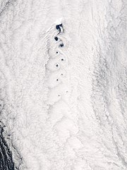
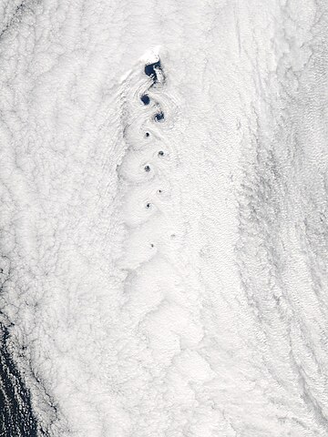
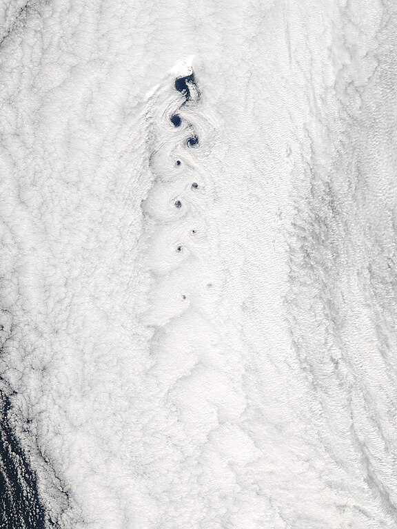
Français : Vue satellite de l'île de Jan Mayen et d'une allée de tourbillons de Karman représentée par les tourbillons dans les nuages, mer du Groenland (en haut) et de Norvège (en bas) English: Satellite view of Jan Mayen island with a Von Kármán vortex street shown by cloud vortices, Greenland (on the top) and Norway (on the bottom) Seas |
| Date | |
| Source | http://rapidfire.sci.gsfc.nasa.gov/gallery/?2005136-0516/JanMayen.A2005136.1255.1km.jpg |
| Author | Image courtesy of MODIS Rapid Response Project at NASA/GSFC |
| Permission (Reusing this file) |
http://rapidfire.sci.gsfc.nasa.gov/faq/#faq01 |
Licensing edit
| This file is in the public domain in the United States because it was solely created by NASA. NASA copyright policy states that "NASA material is not protected by copyright unless noted". (See Template:PD-USGov, NASA copyright policy page or JPL Image Use Policy.) | ||
 |
Warnings:
|
File history
Click on a date/time to view the file as it appeared at that time.
| Date/Time | Thumbnail | Dimensions | User | Comment | |
|---|---|---|---|---|---|
| current | 14:04, 11 April 2007 | | 1,200 × 1,600 (258 KB) | Rémih (talk | contribs) | {{Information |Description={{fr|Vue satellite de l'île de Jan Mayen et d'une allée de tourbillons de Karman représentée par les tourbillons dans les nuages, mer du Groenland (en haut) et de Norvège (en bas)}}{{en|Satellite view of Jan Mayen island wi |
You cannot overwrite this file.
File usage on Commons
The following 2 pages use this file:
File usage on other wikis
The following other wikis use this file:
- Usage on de.wikipedia.org