File:Jemez Pueblo, New Mexico (101306193).jpg
Original file (1,600 × 1,200 pixels, file size: 726 KB, MIME type: image/jpeg)
Captions
Captions
Summary edit
.jpg&action=edit§ion=1)
| Description |
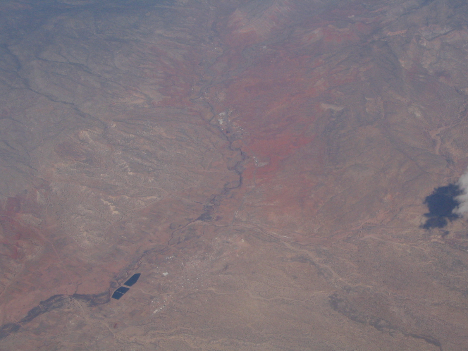
Jemez River valley near the junction of U.S. 550 and S.R. 4. The town of Jemez Pueblo sits near the fishing ponds. Jemez Pueblo is a census-designated place (CDP) in Sandoval County, New Mexico, United States. The population was 1,953 at the 2000 census. It is part of the Albuquerque Metropolitan Statistical Area. The CDP is named after the pueblo at its center. Among Pueblo members it is known as Walatowa. As much as 70% of the 1,890 Jemez People were living on their reservation lands in the early 1970s. Though by then an increasing number were switching to wage-earning work rather than agriculture, the residents continued to raise chile peppers, corn, and wheat, to speak their native language, and to maintain customary practices. Running, an old Jemez pastime and ceremonial activity, grew even more popular than it had been before World War II. Prior to the advent of television at Jemez, tales of running feats had been a major form of entertainment on winter nights. Races continued to hold their ceremonial place as the years passed, their purpose being to assist the movement of the sun and moon or to hasten the growth of crops, for example. At the same time, they became a popular secular sport. The year 1959 saw the first annual Jemez All-Indian Track and Field Meet, won by runners from Jemez seven times in the first ten years. A Jemez runner, Steve Gachupin, won the Pikes Peak Marathon six times, in 1968, setting a record by reaching the top in just 2 hours, 14 minutes, 56 seconds. en.wikipedia.org/wiki/Jemez_Pueblo,_New_Mexico en.wikipedia.org/wiki/Wikipedia:Text_of_Creative_Commons_... |
| Date | |
| Source | Jemez Pueblo, New Mexico |
| Author | Ken Lund from Reno, Nevada, USA |
| Camera location | | View this and other nearby images on: OpenStreetMap |
|---|
.jpg¶ms=035.618163_N_-106.735439_E_globe:Earth_type:camera_source:Flickr_&language=en)
Licensing edit
.jpg&action=edit§ion=2)
- You are free:
- to share – to copy, distribute and transmit the work
- to remix – to adapt the work
- Under the following conditions:
- attribution – You must give appropriate credit, provide a link to the license, and indicate if changes were made. You may do so in any reasonable manner, but not in any way that suggests the licensor endorses you or your use.
- share alike – If you remix, transform, or build upon the material, you must distribute your contributions under the same or compatible license as the original.
| This image was originally posted to Flickr by Ken Lund at https://flickr.com/photos/75683070@N00/101306193. It was reviewed on 3 December 2015 by FlickreviewR and was confirmed to be licensed under the terms of the cc-by-sa-2.0. |
File history
Click on a date/time to view the file as it appeared at that time.
| Date/Time | Thumbnail | Dimensions | User | Comment | |
|---|---|---|---|---|---|
| current | 21:44, 3 December 2015 | | 1,600 × 1,200 (726 KB) | INeverCry (talk | contribs) | Transferred from Flickr via Flickr2Commons |
You cannot overwrite this file.
File usage on Commons
There are no pages that use this file.
.jpg&oldid=467393705)