File:Jews 1490.png

Size of this preview: 800 × 569 pixels. Other resolutions: 320 × 228 pixels | 640 × 455 pixels | 1,024 × 729 pixels | 1,280 × 911 pixels | 2,560 × 1,822 pixels | 3,013 × 2,144 pixels.
Original file (3,013 × 2,144 pixels, file size: 466 KB, MIME type: image/png)
Captions
Captions
Add a one-line explanation of what this file represents

| Description |
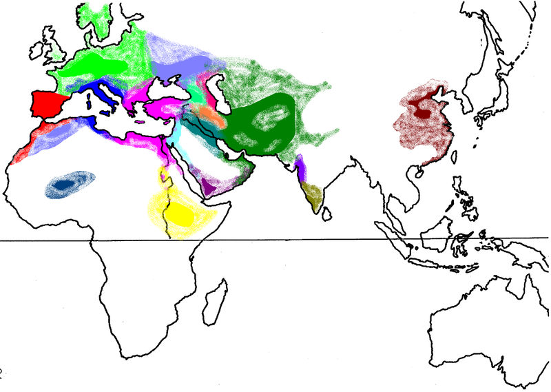
English: Map showing the hearth-areas of assumed Jewish ethnic divisions, circa 1490 AD. Warning: The colored areas are NOT in any way representative of population distribution, population densitiy, or population size of Jews in the year 1490. The map is, at best, only indicative of the existence of the various groups of jewish diaspora in that period. Other authors use rather different groupings and geographic distributions of the described communities.
Deutsch: Karte zur angenommenen Verteilung von vermuteten jüdischen Populationen um das Jahr 1490. Vorsicht: Die farbigen Flächen sind in KEINER Weise repräsentativ für Bevölkerungs-Verteilung, -Dichte oder -Größe, sondern zeigen bestenfalls nur das Bestehen von verschiedenen jüdischen Gemeinschaften in dieser Zeit. Andere Autoren verwenden teils stark abweichende Gruppierungen und geographische Verteilungen der dargestellten Gemeinschaften. |
||||||||
| Date | |||||||||
| Source | Unknown source | ||||||||
| Author | TShilo12 | ||||||||
| Permission (Reusing this file) |
English Wikipedia user TShilo12, the copyright holder of this work, hereby publishes it under the following license:
|
||||||||
| Other versions | File:Mappa Famiglie Ebraiche nel Mondo.gif |

Detail edit
English:
- Europe:
- Italian Jews (Italkim, Sephardi, Ashkenazi and other groups)
- Africa:
- Jews of Bilad el-Sudan (West Africa, Timbuktu)
- Middle East/Caucasus (usually grouped together as Mizrahi Jews):
- India and China (for later periods see also: Baghdadi Jews):
Deutsch:
- Europa:
- Italienische Juden (Italkim, Sephardim, Aschkenasim und weitere Gruppen)
- Afrika (Judentum in Afrika):
- Berberjuden
- mutmaßliche Gemeinschaften in Westafrika, Timbuktu
- Naher Osten/Kaukasus (meist zusammengefasst als Mizrachim):
- Palästinensische Juden (Alter Jischuw)
- Persische sowie Bucharische Juden
- Indien und China:
- Judentum in China (Kaifeng-Gemeinde)
Українська:
- Європа:
- Сефарди (Іберійський півострів та Північно-Західна Африка)
- Римські євреї (Італія та Північно-Центральна Африка)
- Романіоти (Греція, Північно-Східна Африка та Мала Азія)
- Африка:
- Берберські євреї (Атлаські гори)
- Євреї Тімбукту
- Ефіопські євреї («фалаша»)
- Середній Схід та Кавказ:
- Палестинські євреї
- Вавілонські та Іракські євреї
- Лахлухи (курдистанські євреї)
- Єменські євреї
- Грузинські євреї
- Гірські євреї
- Перські та Бухарські євреї
- Індія:
- Бней-ісраель (Bene Israel)
- Малабарські євреї
- Китай:
- Китайські євреї
File history
Click on a date/time to view the file as it appeared at that time.
| Date/Time | Thumbnail | Dimensions | User | Comment | |
|---|---|---|---|---|---|
| current | 10:05, 10 May 2009 | | 3,013 × 2,144 (466 KB) | Amakuha (talk | contribs) | {{Information |Description=Map showing the hearth-areas of Jewish ethnic divisions circa 1490 AD. |Source=? |Date=29.04.2007 |Author=TShilo12 |Permission={{GFDL-user-w|en|English Wikipedia|TShilo12}} |other_versions= }} == Detail == |
You cannot overwrite this file.
File usage on Commons
There are no pages that use this file.
File usage on other wikis
The following other wikis use this file:
- Usage on af.wikipedia.org
- Usage on de.wikipedia.org
- Usage on he.wikipedia.org
- Usage on no.wikipedia.org
- Usage on ru.wikipedia.org
- Usage on uk.wikipedia.org