File:Johndayrivermap.png
No higher resolution available.
Johndayrivermap.png (561 × 500 pixels, file size: 396 KB, MIME type: image/png)
Captions
Captions
Add a one-line explanation of what this file represents
Summary edit
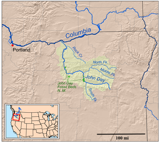
| Description | Map of the John Day River watershed. |
| Date | |
| Source | Self-made, based on USGS data. |
| Author | Kmusser |
Licensing edit
I, the copyright holder of this work, hereby publish it under the following license:
This file is licensed under the Creative Commons Attribution-Share Alike 3.0 Unported license.
- You are free:
- to share – to copy, distribute and transmit the work
- to remix – to adapt the work
- Under the following conditions:
- attribution – You must give appropriate credit, provide a link to the license, and indicate if changes were made. You may do so in any reasonable manner, but not in any way that suggests the licensor endorses you or your use.
- share alike – If you remix, transform, or build upon the material, you must distribute your contributions under the same or compatible license as the original.
File history
Click on a date/time to view the file as it appeared at that time.
| Date/Time | Thumbnail | Dimensions | User | Comment | |
|---|---|---|---|---|---|
| current | 05:05, 26 May 2023 | | 561 × 500 (396 KB) | Jsayre64 (talk | contribs) | add scalebar |
| 20:03, 17 July 2008 |  | 561 × 500 (361 KB) | Kmusser (talk | contribs) | added N.M. | |
| 19:27, 17 July 2008 |  | 561 × 500 (332 KB) | Kmusser (talk | contribs) | == Summary == {{Information |Description=Map of the John Day River watershed. |Source=Self-made, based on USGS data. |Author=Kmusser |Date=July 17, 2008 |Permission= |other_versions= }} [[Category:Maps |
You cannot overwrite this file.
File usage on Commons
The following page uses this file:
File usage on other wikis
The following other wikis use this file:
- Usage on bg.wikipedia.org
- Usage on da.wikipedia.org
- Usage on de.wikipedia.org
- Usage on en.wikipedia.org
- Usage on es.wikipedia.org
- Usage on fr.wikipedia.org
- Usage on it.wikipedia.org
- Usage on ja.wikipedia.org
- Usage on no.wikipedia.org
- Usage on ru.wikipedia.org
- Usage on uk.wikipedia.org
- Usage on www.wikidata.org
- Usage on xmf.wikipedia.org