File:JordanRiver ko.svg

Original file (SVG file, nominally 1,016 × 1,285 pixels, file size: 860 KB)
Captions
Captions
| Description |
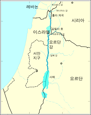
한국어: The 요르단 강. Modified from http://www.un.org/Depts/Cartographic/map/profile/israel.pdf Cross-checked with other maps, especially in the area of the Hula swamp and the tributaries: * Image:Golan 92.jpg from the CIA * [1] from the University of Texas * [2] from [3] * [4] from [5] * [6] from [7]
English: The Jordan River. Modified from http://www.un.org/Depts/Cartographic/map/profile/israel.pdf Cross-checked with other maps, especially in the area of the Hula swamp and the tributaries: * Image:Golan 92.jpg from the CIA * [8] from the University of Texas * [9] from [10] * [11] from [12] * [13] from [14] |
|||
| Date | (translation), 2007-04-06 (upload to Commons) | |||
| Source | translated from JordanRiver en.svg | |||
| Author |
|
|||
| Permission (Reusing this file) |
|

![[1]](http://www.ce.utexas.edu/prof/mckinney/ce397/Topics/Jordan/jordanb.jpg)
![[2]](http://www.idrc.ca/IMAGES/books/907/ch8img3.gif)
![[4]](http://www.think-israel.org/mar05pix/tributaries.gif)
![[6]](http://www.asharqalarabi.org.uk/images1/Image.gif)

|
This SVG file contains embedded text that can be translated into your language, using any capable SVG editor, text editor or the SVG Translate tool. For more information see: About translating SVG files. |
Original upload log edit
This image is a derivative work of the following images:
- File:JordanRiver en.svg licensed with UN map,
- 2007-05-03T16:14:47Z Interiot 1016x1285 (880816 bytes) make the Mediterranean blue
- 2007-04-10T19:34:39Z Interiot 1016x1285 (880621 bytes) make "Yarmouk River" not intersect with the Syria/Jordan border
- 2007-04-10T10:41:25Z Interiot 1016x1285 (880046 bytes) +Yarmouk, +Jabbok
- 2007-04-10T10:23:28Z Interiot 1016x1285 (878471 bytes) +tributaries
- 2007-04-10T09:19:13Z Interiot 1016x1285 (875095 bytes) tweaks
- 2007-04-10T08:07:51Z Interiot 1016x1285 (1061010 bytes) expand default size; +labels
- 2007-04-10T07:53:11Z Interiot 388x491 (1068910 bytes) getting closer...
- 2007-04-06T20:43:05Z Interiot 720x720 (1860366 bytes) '''note: map is still being worked on'''... once complete, English captions will be added here, and a numbered captionless map will be created at [[:Image:JordanRiver_numbered]]. ---- The [[w:Jordan River|Jordan River]].
Translated using SVG Translate
File history
Click on a date/time to view the file as it appeared at that time.
| Date/Time | Thumbnail | Dimensions | User | Comment | |
|---|---|---|---|---|---|
| current | 07:59, 16 September 2014 | | 1,016 × 1,285 (860 KB) | 고려 (talk | contribs) | Upload SVG translation using svgtranslate |
You cannot overwrite this file.
File usage on Commons
The following 2 pages use this file:
File usage on other wikis
The following other wikis use this file:
- Usage on kbp.wikipedia.org
- Usage on ko.wikipedia.org