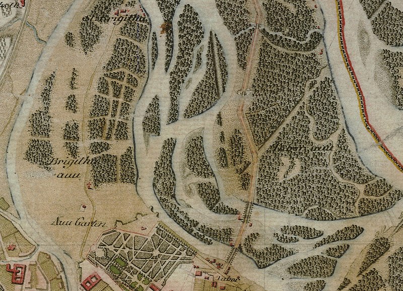
File:Josephinische Landaufnahme 1764 Brigittenau.jpg

Original file (1,425 × 1,030 pixels, file size: 489 KB, MIME type: image/jpeg)
Captions
Captions
Summary edit
| DescriptionJosephinische Landaufnahme 1764 Brigittenau.jpg |
Deutsch: Historische Karte (um 1764) der Brigittenau, dem XX. Gemeindebezirk von Wien / Österreich / Europäische Union.
Landkarte BIXa242 sectio 071 Josephinische Landesaufnahme. Gebiet im Bereich des heutigen Nordwestbahnhofs. Links ist der heutige Donaukanal eingezeichnet, in der Mitte links die unverbaute Alt-Brigittenau mit der Kirche St. Brigitta. Die von Stadt wegführende Straße folgt z.T. der heutigen Jägerstraße. Oben die Brigittakapelle, unten der Augarten und der Bereich Am Tabor. Von den Nebenarmen in der Mitte ist der linke, jener der am Augarten vorbeifließt, das Fahnenstangenwasser. In diesem Bereich befindet sich heute die Nordwestbahnstraße. Auf dem Gebiet der drei Nebenarme liegt heute der Nordwestbahnhof. Der rechte der drei Nebenarme ist das Kaiserwasser. Rechts davon eine Straße, die etwa am Verlauf der heutigen Dresdnerstraße in Zwischenbrücken liegt. Ganz rechts die im Bild der damalige Hauptarm, etwa dort, wo auch heute die Donau fließt. English: Historical map (around 1764) from [:en:Brigittenau Magyar: Bécs |
|||||||||
| Date | Landesaufnahme: von 1764 bis 1787. | |||||||||
| Source |
Josephinische Landesaufnahme / Part of Josephinische Landesaufnahme Wien.jpeg |
|||||||||
| Creator |
Historische Militärkarte der Habsburgermonarchie. |
|||||||||
| Permission (Reusing this file) |
freies Werk | |||||||||
| Geotemporal data | ||||||||||
| Bounding box |
|
|||||||||
| Georeferencing | View the georeferenced map in the Wikimaps Warper | |||||||||
Licensing edit
| Public domainPublic domainfalsefalse |
|
This work is in the public domain in its country of origin and other countries and areas where the copyright term is the author's life plus 70 years or fewer.
| |
| This file has been identified as being free of known restrictions under copyright law, including all related and neighboring rights. | |
https://creativecommons.org/publicdomain/mark/1.0/PDMCreative Commons Public Domain Mark 1.0falsefalse
File history
Click on a date/time to view the file as it appeared at that time.
| Date/Time | Thumbnail | Dimensions | User | Comment | |
|---|---|---|---|---|---|
| current | 10:52, 7 January 2018 |  | 1,425 × 1,030 (489 KB) | Joadl (talk | contribs) | == {{int:filedesc}} == {{Map |Description= {{Multilingual description |de=Historische Landkarte BIXa242 sectio 071 Josephinische Landesaufnahme: Wien und Umgebung, Niederösterreich, Österreich |en=Historical map Josephinische Landesaufnahme 1764-... |
You cannot overwrite this file.
File usage on Commons
The following 2 pages use this file:
File usage on other wikis
The following other wikis use this file:
- Usage on de.wikipedia.org
Metadata
This file contains additional information such as Exif metadata which may have been added by the digital camera, scanner, or software program used to create or digitize it. If the file has been modified from its original state, some details such as the timestamp may not fully reflect those of the original file. The timestamp is only as accurate as the clock in the camera, and it may be completely wrong.
| Camera manufacturer | NLib Universal |
|---|---|
| Camera model | NImageFileJPG 1.0.1 |
| JPEG file comment | Ashampoo Snap Business |
| Width | 1,425 px |
| Height | 1,030 px |
| Orientation | Normal |
| Horizontal resolution | 96 dpi |
| Vertical resolution | 96 dpi |
| Software used | NImageFileJPG 1.0.0 |
| File change date and time | 10:20, 6 January 2018 |
| Exif version | 2.21 |
| Date metadata was last modified | 12:48, 7 January 2018 |
| Rating (out of 5) | 5 |
| Unique ID of original document | 24CA8A8F41F6512FCAF1460173974831 |
| Keywords |
|
| IIM version | 4 |