File:Josephinische Landaufnahme pg199.jpg

Size of this preview: 800 × 528 pixels. Other resolutions: 320 × 211 pixels | 640 × 422 pixels | 1,024 × 675 pixels | 1,280 × 844 pixels | 2,560 × 1,688 pixels | 7,873 × 5,192 pixels.
Original file (7,873 × 5,192 pixels, file size: 23.51 MB, MIME type: image/jpeg)
Captions
Captions
Add a one-line explanation of what this file represents
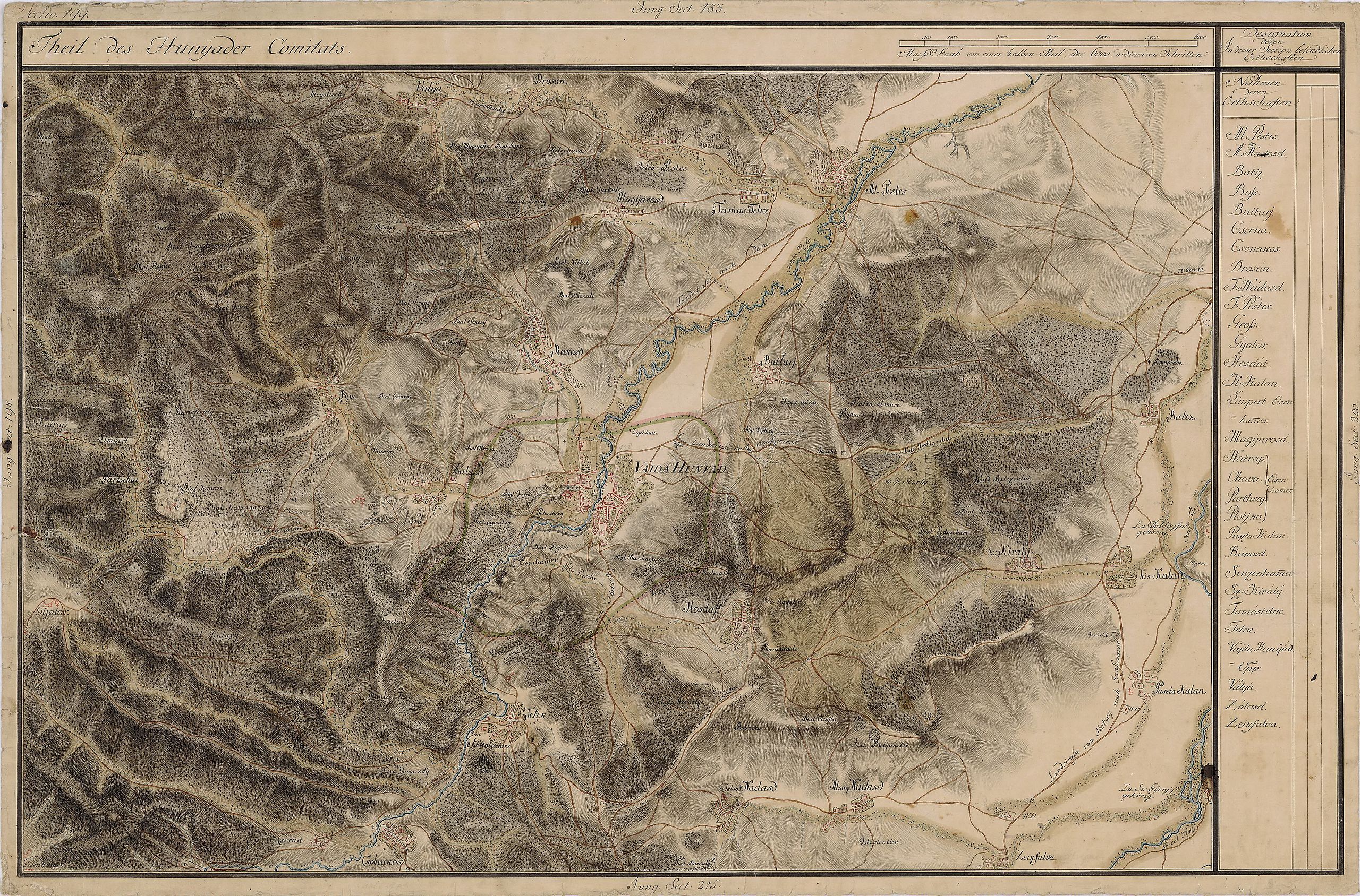
| Name shown on the map Nume din hartă |
Administrative unit Unitate administrativă |
Romanian name Numele românesc |
Hungarian name Numele unguresc |
German name Numele german |
Country today Ţara de astăzi |
|---|---|---|---|---|---|
| Gross | Hunyad megye ro:Comitatul Hunedoara |
Groş | Grós | Gross | Romania |
| Válya | Hunyad megye | Valea Nandrului | Nándorválya | Weissenthal | Romania |
| Drosan | Hunyad megye | Josani | Zsoszány | Susendorf | Romania |
| Magyarosd | Hunyad megye | Mănerău | Magyarosd | Nussdorf | Romania |
| Felsõ Pestes | Hunyad megye | Pestişu Mic | Felsõpestes | Romania | |
| Tamas Telke | Hunyad megye | Peştişu Mare | Tamástelke, Alpestes | Unter-Peschtendorf | Romania |
| Al. Pestes | Hunyad megye | Peştişu Mare | Alpestes | Unter-Peschtendorf | Romania |
| Batiz | Hunyad megye | Batiz | Batiz, Batizfalva, Sajtostelek | Batiz, Batiss | Romania |
| Buiturj | Hunyad megye | Buituri, Hunedoara | Bujtur, Vajdahunyad | Romania | |
| Rakosd | Hunyad megye | Răcăştia | Rákosd | Romania | |
| Bos | Hunyad megye | Boş | Bós, Bózs, Boz | Romania | |
| Ohaka | Hunyad megye | Boş | Bós része | Romania | |
| Nacrap | Hunyad megye | Romania | |||
| Limpert | Hunyad megye | Govăşdia | Limpert, Ólimpert, Felsőlimpert, Alsólimpert | Ober Limpert, Unter Limpert | Romania |
| Gyalár | Hunyad megye | Ghelari | Gyalár | Romania | |
| Partschai | Hunyad megye | Romania | |||
| Zalasd | Hunyad megye | Zlaşti | Zalasd, Vajdahunyad | Romania | |
| Vaida Hunyad | Hunyad megye | Hunedoara | Vajdahunyad, Hunyad | Eisenmarkt, Eisenstadt, Hunyad, Thurndorf | Romania |
| Hosdat | Hunyad megye | Hăşdat | Hosdát | Hochstatt, Hochstätten | Romania |
| Sz. Kiraly | Hunyad megye | Sâncrai | Szentkirály | Romania | |
| Kis Kalan | Hunyad megye | Călanu Mic | Kiskalán, Kalán, Kiskaján, Kajánel | Klein-Klandorf, Löffeldorf | Romania |
| Puszta Kalan | Hunyad megye | Călan | Pusztakalán | Klandorf, Kalan | Romania |
| Boldogfalva, Zu Boldogfal gehörig | Hunyad megye | Sântămăria de Piatră | Kőboldogfalva, Boldogasszonyfalva | Mariendorf, Liebfrauendorf | Romania |
| Sz. Gyorgy, Zu Sz. Gyorgy gehörig | Hunyad megye | Streisângeorgiu | Sztrigyszentgyörgy, Szentgyörgy | Romania | |
| Also Nadasd | Hunyad megye | Nădăştia de Jos | Alsónádasd, Alsónádas | Unter-Rohrbach | Romania |
| Telek | Hunyad megye | Teliucu Inferior | Alsótelek, Telek | Untertelek, Eisenhammer | Romania |
| Ploczka | Hunyad megye | Ploscăbaia | Gyalár, Ploszkabánya | Romania | |
| Cserna | Hunyad megye | Cerna [Cerna-Păroasa] | Csolnakos | Romania | |
| Csolnakos | Hunyad megye | Cinciş-Cerna | Csolnakos | Romania |
Summary edit
| Description |
English: Grand Duchy of Transylvania, 1769-1773. Josephinische Landaufnahme pg.199 Română: Harta Iosefină a Transilvaniei, 1769-1773. Josephinische Landaufnahme pg.199 |
||||
| Date | between 1769 and 1773 | ||||
| Source | Österreichisches Staatsarchiv, Kriegsarchiv, B IX 715: Original-Aufnahmskarte des Grossfürtenthums Siebenbürgen. Geometrisch aufgenommen und bearbeitet in den Jahren 1769 bis 1773 unter der Direction des Obristen von Fabris, theils durch Officiere des grossen Feld-Generalstabes, theils auch von verschiedenen aus dem in Siebenbürgen bequartierten Regimentern zu diesem Geschäfte beigezogenen Individuen | ||||
| Author | Historische Militärkarte der österreichisch-ungarischen Monarchie | ||||
| Permission (Reusing this file) |
|
||||
Clickable Map of the Grand Duchy of Transylvania edit
File history
Click on a date/time to view the file as it appeared at that time.
| Date/Time | Thumbnail | Dimensions | User | Comment | |
|---|---|---|---|---|---|
| current | 22:17, 8 December 2009 | | 7,873 × 5,192 (23.51 MB) | Asybaris01 (talk | contribs) | good rezolution |
| 10:56, 3 October 2009 |  | 5,432 × 3,582 (17.58 MB) | Asybaris01 (talk | contribs) | {{Information |Description={{ro|1=Josephinische Landaufnahme pg199}} |Source=Josephinische Landaufnahme pg199 |Author=Asybaris01 |Date=10/03/2009 |Permission= |other_versions= }} |
You cannot overwrite this file.
File usage on Commons
The following page uses this file:
File usage on other wikis
The following other wikis use this file:
- Usage on arz.wikipedia.org
- Usage on eo.wikipedia.org
- Usage on hu.wikipedia.org
- Usage on ro.wikipedia.org
- Hunedoara
- Călan
- Batiz, Hunedoara
- Boș, Hunedoara
- Călanu Mic, Hunedoara
- Govăjdia, Hunedoara
- Groș, Hunedoara
- Hășdat, Hunedoara
- Josani, Hunedoara
- Mănerău, Hunedoara
- Nădăștia de Jos, Hunedoara
- Pestișu Mic, Hunedoara
- Peștișu Mare, Hunedoara
- Răcăștia, Hunedoara
- Sâncrai, Hunedoara
- Sântămăria de Piatră, Hunedoara
- Streisângeorgiu, Hunedoara
- Teliucu Inferior, Hunedoara
- Valea Nandrului, Hunedoara
- Ghelari, Hunedoara
- Comuna Pestișu Mic, Hunedoara
- Zlaști, Hunedoara
- Usage on tt.wikipedia.org
- Usage on www.wikidata.org