File:Josephinische Landaufnahme pg200.jpg

Size of this preview: 800 × 526 pixels. Other resolutions: 320 × 210 pixels | 640 × 421 pixels | 1,024 × 673 pixels | 1,280 × 842 pixels | 2,560 × 1,683 pixels | 8,457 × 5,560 pixels.
Original file (8,457 × 5,560 pixels, file size: 24.37 MB, MIME type: image/jpeg)
Captions
Captions
Add a one-line explanation of what this file represents
| Name shown on the map Nume din hartă |
Administrative unit Unitate administrativă |
Romanian name Numele românesc |
Hungarian name Numele unguresc |
German name Numele german |
Country today Ţara de astăzi |
|---|---|---|---|---|---|
| Tompa | Hunyad megye ro:Comitatul Hunedoara |
Tâmpa | Tompa | Romania | |
| Lósád | Hunyad megye | Jeledinţi | Lozsád | Lozsád, Lozsádkistóti | Romania |
| Szászváros | Szászváros szék Brooser Stuhl Scaunul Orăştiei |
Orăştie | Szászváros | Broos, Brosz, Saxopolis, Ambrosiopolis | Romania |
| Nagy Denk | Hunyad megye | Dâncu Mare | Nagydenk, Felsődenk, Mártondenk, Denk | Romania | |
| Valya | Hunyad megye | Valea Sângeorgiului | Szentgyörgyválya, Vályaszentgyörgy, Válya | Gergesthal | Romania |
| Petreny | Hunyad megye | Petreni | Petrény | Romania | |
| Piski | Hunyad megye | Simeria Veche | Ópiski | Romania | |
| Pad | Hunyad megye | Spini | Pád | Romania | |
| Tordas | Szászváros szék | Turdaş | Tordos | Thorendorf[in Unterwald] | Romania |
| Benk Szász | Szászváros szék | Pricaz | Perkász | Perkaß [in Unterwaldes] | Romania |
| Martinesd | Hunyad megye | Mărtineşti | Martinesd, Mártondenk | Martensdorf | Romania |
| Repas | Hunyad megye | Râpaş | Répás, Nagyrépás | Rübendorf | Romania |
| Bastya | Hunyad megye | Băcia | Bácsi, Alsóbácsi | Schäferdorf | Romania |
| Toti | Hunyad megye | Totia | Nagytóti | Ratzdorf | Romania |
| Tormás | Hunyad megye | Turmaş | Tormás | Krenndorf | Romania |
| Kaszto | Szászváros szék | Căstău | Kasztó | Kastendorf [in Unterwaldes] | Romania |
| Szamos | Hunyad megye | Romania | |||
| Büster | Hunyad megye | Jeledinţi | Büszter, Lozsád | Romania | |
| Magura | Hunyad megye | Măgura | Magura | Romania | |
| Tamaspatak | Hunyad megye | Tămăşasa | Tamáspatak | Romania | |
| Berény | Szászváros szék | Beriu | Berény | Lammdorf, Bärend [in Unterwaldes] | Romania |
| Szereka | Szászváros szék | Sereca | Szereka | Elsterdorf, Rodomersdorf [in Unterwald] | Romania |
| Kis Denk | Hunyad megye | Dâncu Mic | Kisdenk | Romania | |
| Kõ Boldogfalva | Hunyad megye | Sântămăria de Piatră | Kőboldogfalva, Boldogasszonyfalva | Mariendorf, Liebfrauendorf | Romania |
| Szátsál | Hunyad megye | Strei-Săcel | Sztrigyszacsal | Romania | |
| Also Varosvize | Hunyad megye | Orăştioara de Jos | Alsóváros | Burgbach | Romania |
| Sebeshely | Szászváros szék | Sibişel | Ósebeshely, Felsősebes, Kissebes | Alt-Schebeschel, Sebeschel [in Unterwald] | Romania |
| Szent Gyorgy | Hunyad megye | Streisângeorgiu | Sztrigyszentgyörgy, Szentgyörgy | Romania |
Summary edit
| Description |
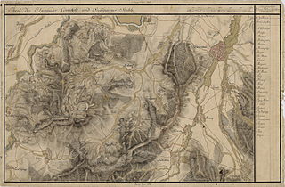
English: Grand Duchy of Transylvania, 1769-1773. Josephinische Landaufnahme pg.200 Română: Harta Iosefină a Transilvaniei, 1769-1773. Josephinische Landaufnahme pg.200 |
||||
| Date | between 1769 and 1773 | ||||
| Source | Österreichisches Staatsarchiv, Kriegsarchiv, B IX 715: Original-Aufnahmskarte des Grossfürtenthums Siebenbürgen. Geometrisch aufgenommen und bearbeitet in den Jahren 1769 bis 1773 unter der Direction des Obristen von Fabris, theils durch Officiere des grossen Feld-Generalstabes, theils auch von verschiedenen aus dem in Siebenbürgen bequartierten Regimentern zu diesem Geschäfte beigezogenen Individuen | ||||
| Author | Historische Militärkarte der österreichisch-ungarischen Monarchie | ||||
| Permission (Reusing this file) |
|
||||
Clickable Map of the Grand Duchy of Transylvania edit
File history
Click on a date/time to view the file as it appeared at that time.
| Date/Time | Thumbnail | Dimensions | User | Comment | |
|---|---|---|---|---|---|
| current | 22:21, 8 December 2009 | | 8,457 × 5,560 (24.37 MB) | Asybaris01 (talk | contribs) | good rezolution |
| 11:00, 3 October 2009 |  | 5,497 × 3,614 (16.74 MB) | Asybaris01 (talk | contribs) | {{Information |Description={{ro|1=Josephinische Landaufnahme pg200}} |Source=Josephinische Landaufnahme pg200 |Author=Asybaris01 |Date=10/03/2009 |Permission= |other_versions= }} |
You cannot overwrite this file.
File usage on Commons
There are no pages that use this file.
File usage on other wikis
The following other wikis use this file:
- Usage on arz.wikipedia.org
- Usage on hu.wikipedia.org
- Usage on ro.wikipedia.org
- Orăștie
- Călan
- Simeria
- Sereca, Hunedoara
- Băcia, Hunedoara
- Beriu, Hunedoara
- Căstău, Hunedoara
- Dâncu Mare, Hunedoara
- Dâncu Mic, Hunedoara
- Jeledinți, Hunedoara
- Măgura, Hunedoara
- Mărtinești, Hunedoara
- Orăștioara de Jos, Hunedoara
- Petreni, Hunedoara
- Pricaz, Hunedoara
- Râpaș, Hunedoara
- Sântămăria de Piatră, Hunedoara
- Sibișel (Beriu), Hunedoara
- Simeria Veche, Hunedoara
- Spini, Hunedoara
- Strei-Săcel, Hunedoara
- Streisângeorgiu, Hunedoara
- Tămășasa, Hunedoara
- Tâmpa, Hunedoara
- Totia, Hunedoara
- Turdaș, Hunedoara
- Turmaș, Hunedoara
- Valea Sângeorgiului, Hunedoara
- Usage on tt.wikipedia.org
View more global usage of this file.