File:Josephinische Landaufnahme pg222.jpg

Size of this preview: 800 × 524 pixels. Other resolutions: 320 × 210 pixels | 640 × 419 pixels | 1,024 × 671 pixels | 1,280 × 838 pixels | 2,560 × 1,676 pixels | 8,449 × 5,533 pixels.
Original file (8,449 × 5,533 pixels, file size: 24.06 MB, MIME type: image/jpeg)
Captions
Captions
Add a one-line explanation of what this file represents
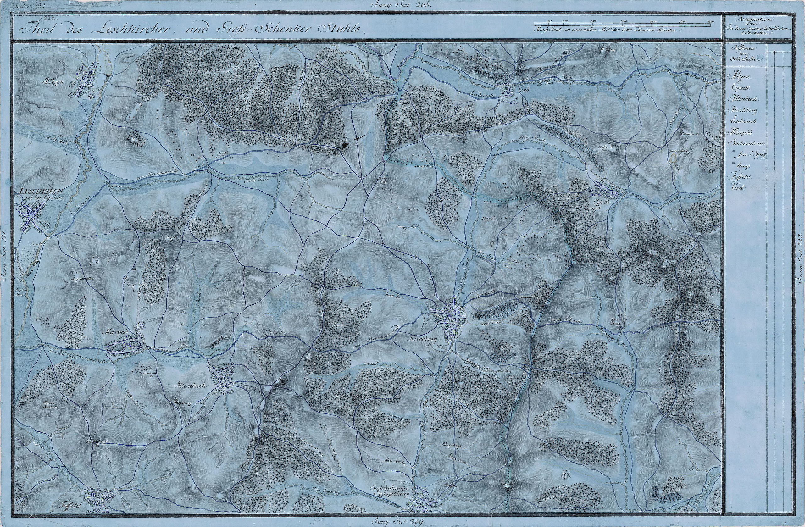
| Name shown on the map Nume din hartă |
Administrative unit Unitate administrativă |
Romanian name Numele românesc |
Hungarian name Numele unguresc |
German name Numele german |
Country today Ţara de astăzi |
|---|---|---|---|---|---|
| Altzen | Újegyház szék Leschkircher Stuhl Scaunul Nocrich |
Alţâna | Alcina | Alzen | Romania |
| Verd | Nagysink szék Grossschenker Stuhlt Scaunul Cincului |
Vărd | Vérd | Werd | Romania |
| Leschkirch vel Uj Egyház |
Újegyház szék Leschkircher Stuhl Scaunul Nocrich |
Nocrich | Újegyház | Leschkirch | Romania |
| Cziedt vel Veszszõd |
Nagysink szék Grossschenker Stuhlt Scaunul Cincului |
Veseud (Chirpăr) | Vessződ | Zied | Romania |
| Márpod | Újegyház szék Leschkircher Stuhl Scaunul Nocrich |
Marpod | Márpod | Marpod | Romania |
| Kirchberg | Újegyház szék Leschkircher Stuhl Scaunul Nocrich |
Chirpăr | Kürpöd | Kirchberg | Romania |
| Illenbach | Újegyház szék Leschkircher Stuhl Scaunul Nocrich |
Ilimbav | Illenbák | Illenbach | Romania |
| Sachsenhausen v Szászahusz |
Újegyház szék Leschkircher Stuhl Scaunul Nocrich |
Săsăuş | Szászház | Sachsenhausen | Romania |
| Foffeld | Újegyház szék Leschkircher Stuhl Scaunul Nocrich |
Fofeldea | Hóföld | Hochfeld | Romania |
Summary edit
| Description |
English: Grand Duchy of Transylvania, 1769-1773. Josephinische Landaufnahme pg.222 Română: Harta Iosefină a Transilvaniei, 1769-1773. Josephinische Landaufnahme pg.222 |
||||
| Date | between 1769 and 1773 | ||||
| Source | Österreichisches Staatsarchiv, Kriegsarchiv, B IX 715: Original-Aufnahmskarte des Grossfürtenthums Siebenbürgen. Geometrisch aufgenommen und bearbeitet in den Jahren 1769 bis 1773 unter der Direction des Obristen von Fabris, theils durch Officiere des grossen Feld-Generalstabes, theils auch von verschiedenen aus dem in Siebenbürgen bequartierten Regimentern zu diesem Geschäfte beigezogenen Individuen | ||||
| Author | Historische Militärkarte der österreichisch-ungarischen Monarchie | ||||
| Permission (Reusing this file) |
|
||||
Clickable Map of the Grand Duchy of Transylvania edit
File history
Click on a date/time to view the file as it appeared at that time.
| Date/Time | Thumbnail | Dimensions | User | Comment | |
|---|---|---|---|---|---|
| current | 08:29, 28 December 2009 | | 8,449 × 5,533 (24.06 MB) | Asybaris01 (talk | contribs) | new rez |
| 11:57, 3 October 2009 |  | 5,492 × 3,596 (16.29 MB) | Asybaris01 (talk | contribs) | {{Information |Description={{ro|1=Josephinische Landaufnahme pg222}} |Source=Josephinische Landaufnahme pg222 |Author=Asybaris01 |Date=10/03/2009 |Permission= |other_versions= }} |
You cannot overwrite this file.
File usage on Commons
The following page uses this file:
File usage on other wikis
The following other wikis use this file:
- Usage on arz.wikipedia.org
- Usage on hu.wikipedia.org
- Usage on la.wikipedia.org
- Usage on ro.wikipedia.org
- Usage on tt.wikipedia.org
- Usage on www.wikidata.org