File:Josephinische Landaufnahme pg254.jpg

Size of this preview: 721 × 600 pixels. Other resolutions: 289 × 240 pixels | 577 × 480 pixels | 924 × 768 pixels | 1,231 × 1,024 pixels | 2,463 × 2,048 pixels | 8,427 × 7,008 pixels.
Original file (8,427 × 7,008 pixels, file size: 32.1 MB, MIME type: image/jpeg)
Captions
Captions
Add a one-line explanation of what this file represents
| Warning | The original file is very high-resolution. It might not load properly or could cause your browser to freeze when opened at full size. |
|---|
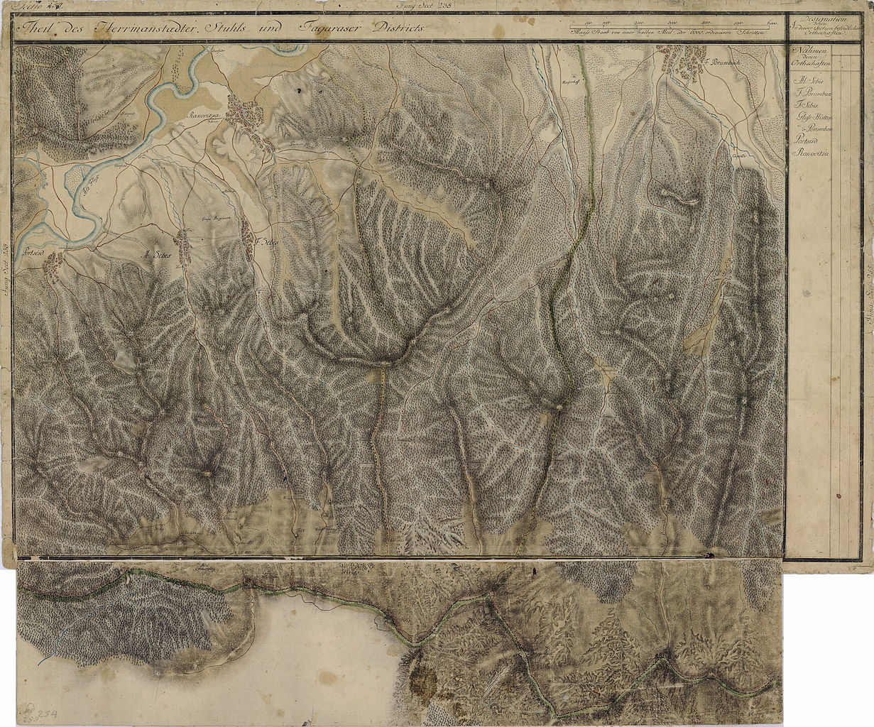
| Name shown on the map Nume din hartă |
Administrative unit Unitate administrativă |
Romanian name Numele românesc |
Hungarian name Numele unguresc |
German name Numele german |
Country today Ţara de astăzi |
|---|---|---|---|---|---|
| F. Porumbach | Fogaras kerület Komitat Fogarasch Districtul Făgăraş |
Porumbacu de Sus | Felsõporumbák | Ober-Bornbach | Romania |
| Glas Hûtten | Fogaras kerület Komitat Fogarasch Districtul Făgăraş |
cătunul La Glăjărie(vezi) | Felsõporumbák -tól délre | Romania | |
| Rakovitza | Szeben szék Hauptstuhl Hermannstadt Scaunul Sibiului |
Racoviţa | Oltrákovica | Rakovitza Rakevets |
Romania |
| Portsesd | Szeben szék Hauptstuhl Hermannstadt Scaunul Sibiului |
Turnu Roşu(Porceşti) | Vöröstorony, Porcsesd | Schweinsdorf | Romania |
| A. Sebes | Szeben szék Hauptstuhl Hermannstadt Scaunul Sibiului |
Sebeşu de Sus | Oltfelsősebes, Felsősebes | Ober-Schewesch Ober-Schewisch |
Romania |
| F. Sebes | Szeben szék Hauptstuhl Hermannstadt Scaunul Sibiului |
Sebeşu de Jos | Oltalsósebes, Alsósebes | Unter-Schewesch, Unter-Schewisch | Romania |
Summary edit
| Description |
English: Grand Duchy of Transylvania, 1769-1773. Josephinische Landaufnahme pg.254 Română: Harta Iosefină a Transilvaniei, 1769-1773. Josephinische Landaufnahme pg.254 |
||||
| Date | between 1769 and 1773 | ||||
| Source | Österreichisches Staatsarchiv, Kriegsarchiv, B IX 715: Original-Aufnahmskarte des Grossfürtenthums Siebenbürgen. Geometrisch aufgenommen und bearbeitet in den Jahren 1769 bis 1773 unter der Direction des Obristen von Fabris, theils durch Officiere des grossen Feld-Generalstabes, theils auch von verschiedenen aus dem in Siebenbürgen bequartierten Regimentern zu diesem Geschäfte beigezogenen Individuen | ||||
| Author | Historische Militärkarte der österreichisch-ungarischen Monarchie | ||||
| Permission (Reusing this file) |
|
||||
Clickable Map of the Grand Duchy of Transylvania edit
File history
Click on a date/time to view the file as it appeared at that time.
| Date/Time | Thumbnail | Dimensions | User | Comment | |
|---|---|---|---|---|---|
| current | 17:15, 3 December 2009 | | 8,427 × 7,008 (32.1 MB) | Asybaris01 (talk | contribs) | verry good rezolution |
| 07:00, 3 October 2009 |  | 4,888 × 4,065 (7.84 MB) | Asybaris01 (talk | contribs) | {{Information |Description={{ro|1=Josephinische Landaufnahme pg.254}} |Source=Josephinische Landaufnahme pg.254 |Author=Asybaris01 |Date=10/03/2009 |Permission= |other_versions= }} Category:Josephinische Landaufnahme |
You cannot overwrite this file.
File usage on Commons
There are no pages that use this file.
File usage on other wikis
The following other wikis use this file:
- Usage on ro.wikipedia.org