File:Joshua tree national-park map.jpg

Size of this preview: 800 × 386 pixels. Other resolutions: 320 × 154 pixels | 640 × 309 pixels | 1,024 × 494 pixels | 1,280 × 617 pixels | 2,560 × 1,235 pixels | 6,774 × 3,267 pixels.
Original file (6,774 × 3,267 pixels, file size: 1.64 MB, MIME type: image/jpeg)
Captions
Captions
Add a one-line explanation of what this file represents
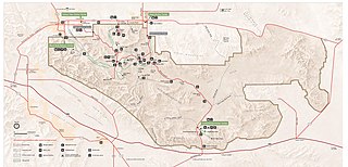
| Description | Map of Joshua Tree National Park — in the Mojave Desert, eastern Southern California. |
| Date | downloaded 2012-01 |
| Source | http://www.nps.gov/jotr/planyourvisit/upload/jotrmap.pdf |
| Author | National Park Service |
| Permission (Reusing this file) |
PD-USGov-NPS |
| This image or media file contains material based on a work of a National Park Service employee, created as part of that person's official duties. As a work of the U.S. federal government, such work is in the public domain in the United States. See the NPS website and NPS copyright policy for more information. |
File history
Click on a date/time to view the file as it appeared at that time.
| Date/Time | Thumbnail | Dimensions | User | Comment | |
|---|---|---|---|---|---|
| current | 04:02, 6 January 2012 | | 6,774 × 3,267 (1.64 MB) | Jarekt (talk | contribs) | Updated 2011 version from http://www.nps.gov/jotr/planyourvisit/upload/jotrmap.pdf |
| 06:49, 27 March 2006 |  | 1,245 × 593 (563 KB) | Huebi~commonswiki (talk | contribs) | {{PD-USGov-NPS}} |
You cannot overwrite this file.
File usage on Commons
The following page uses this file:
File usage on other wikis
The following other wikis use this file:
- Usage on de.wikipedia.org
- Usage on de.wikivoyage.org
- Usage on eo.wikipedia.org
- Usage on es.wikipedia.org
- Usage on eu.wikipedia.org
- Usage on he.wikipedia.org
- Usage on hu.wikipedia.org
- Usage on pl.wikipedia.org
- Usage on pt.wikipedia.org
- Usage on tr.wikipedia.org