File:Junction Road - geograph.org.uk - 212554.jpg
Junction_Road_-_geograph.org.uk_-_212554.jpg (640 × 479 pixels, file size: 126 KB, MIME type: image/jpeg)
File information
Structured data
Captions
Captions
Add a one-line explanation of what this file represents
Summary edit
| DescriptionJunction Road - geograph.org.uk - 212554.jpg |
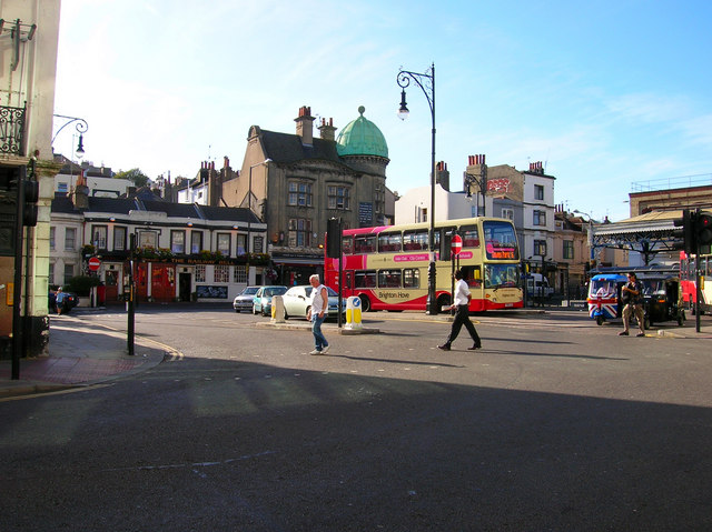
English: Junction Road. Head north along Surrey Street until you reach the Railway Belle pub then turn east. The buildings on the western side originally continued up to the entrance of the station but was causing traffic problems by the 1920s when it was decided to link Queens Road to Surrey Street. The victim was the Terminus Hotel which was demolished to make way for it. Consequently, Junction Road is the length of two buses. The two pubs next to each other are the Railway Belle to the left and Grand Central to the right. The latter originally opened as the Railway Hotel in the 1860s the upstairs of which was converted into a 50 seat theatre in the 1970s called the Nightingale. The theatre closed for 7 years as the pub below changed hands but it has recently reopened again. To the right of the bus with the union jack frontage is a tuctuc, ubiquitous in the Asian subcontinent, and introduced to Brighton streets in June 2006 where they have become enormously popular. At present they only served Hove and the Marina and are cheaper than both bus and taxi. Not surprisingly they are not very popular with the latter. How they cope with the south westerly gales during the autumn will be interesting to see.
Click on the link to take you to the next page. https://www.geograph.org.uk/photo/212557 |
| Date | |
| Source | From geograph.org.uk |
| Author | Simon Carey |
| Attribution (required by the license) InfoField | Simon Carey / Junction Road / |
InfoField | Simon Carey / Junction Road |
| Camera location | 50° 49′ 42″ N, 0° 08′ 31″ W | View this and other nearby images on: OpenStreetMap |
|---|
| Object location | 50° 49′ 42″ N, 0° 08′ 31″ W | View this and other nearby images on: OpenStreetMap |
|---|
Licensing edit

|
This image was taken from the Geograph project collection. See this photograph's page on the Geograph website for the photographer's contact details. The copyright on this image is owned by Simon Carey and is licensed for reuse under the Creative Commons Attribution-ShareAlike 2.0 license.
|
This file is licensed under the Creative Commons Attribution-Share Alike 2.0 Generic license.
Attribution: Simon Carey
- You are free:
- to share – to copy, distribute and transmit the work
- to remix – to adapt the work
- Under the following conditions:
- attribution – You must give appropriate credit, provide a link to the license, and indicate if changes were made. You may do so in any reasonable manner, but not in any way that suggests the licensor endorses you or your use.
- share alike – If you remix, transform, or build upon the material, you must distribute your contributions under the same or compatible license as the original.
File history
Click on a date/time to view the file as it appeared at that time.
| Date/Time | Thumbnail | Dimensions | User | Comment | |
|---|---|---|---|---|---|
| current | 22:26, 31 January 2010 |  | 640 × 479 (126 KB) | GeographBot (talk | contribs) | == {{int:filedesc}} == {{Information |description={{en|1=Junction Road. Head north along Surrey Street until you reach the Railway Belle pub then turn east. The buildings on the western side originally continued up to the entrance of the station but was c |
You cannot overwrite this file.
File usage on Commons
There are no pages that use this file.
Metadata
This file contains additional information such as Exif metadata which may have been added by the digital camera, scanner, or software program used to create or digitize it. If the file has been modified from its original state, some details such as the timestamp may not fully reflect those of the original file. The timestamp is only as accurate as the clock in the camera, and it may be completely wrong.
| Camera manufacturer | NIKON |
|---|---|
| Camera model | E4600 |
| Exposure time | 116,171/25,000,000 sec (0.00464684) |
| F-number | f/4.9 |
| ISO speed rating | 50 |
| Date and time of data generation | 18:03, 30 July 2006 |
| Lens focal length | 5.7 mm |
| Orientation | Normal |
| Horizontal resolution | 300 dpi |
| Vertical resolution | 300 dpi |
| Software used | PictureProject 1.1.0 M |
| File change date and time | 19:52, 30 July 2006 |
| Y and C positioning | Centered |
| Exposure Program | Normal program |
| Exif version | 2.2 |
| Date and time of digitizing | 18:03, 30 July 2006 |
| APEX exposure bias | 0 |
| Maximum land aperture | 3 APEX (f/2.83) |
| Metering mode | Pattern |
| Light source | Unknown |
| Flash | Flash did not fire, auto mode |
| Color space | sRGB |
