File:K129 HGE recoverysite.png
Size of this preview: 610 × 600 pixels. Other resolutions: 244 × 240 pixels | 488 × 480 pixels | 657 × 646 pixels.
Original file (657 × 646 pixels, file size: 53 KB, MIME type: image/png)
Captions
Captions
Add a one-line explanation of what this file represents
Summary edit
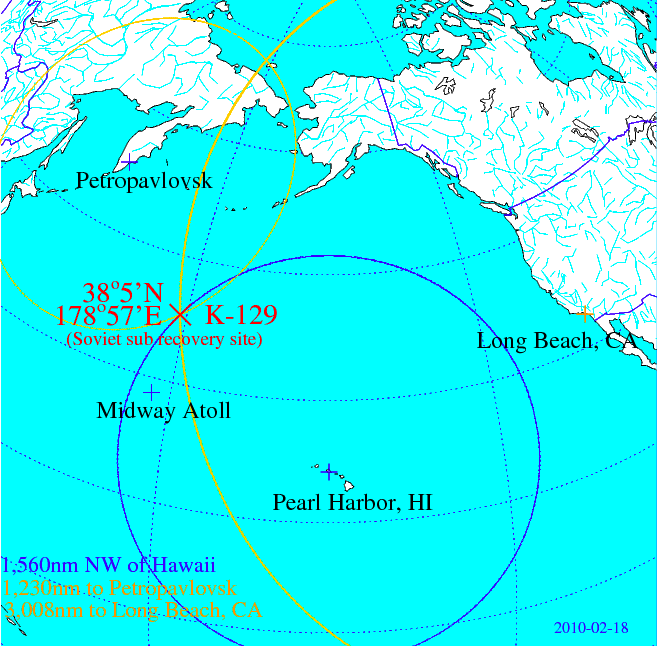
| Description | Map depicting the location of K-129 (Soviet Golf II class strategic ballistic missile submarine), which was (partially?) recovered by the USNS Hughes Glomar Explorer |
| Date | |
| Source | Own work, based on FOIA release specifying distance of recovery site to Long Beach, CA, and Hawaii, respectively. |
| Author | Enemenemu |
Licensing edit
| I, the copyright holder of this work, release this work into the public domain. This applies worldwide. In some countries this may not be legally possible; if so: I grant anyone the right to use this work for any purpose, without any conditions, unless such conditions are required by law. |
File history
Click on a date/time to view the file as it appeared at that time.
| Date/Time | Thumbnail | Dimensions | User | Comment | |
|---|---|---|---|---|---|
| current | 22:03, 8 April 2015 | | 657 × 646 (53 KB) | RokerHRO (talk | contribs) | optipng -o7 -i0 → 48.98% decrease |
| 23:41, 18 February 2010 |  | 657 × 646 (104 KB) | Enemenemu (talk | contribs) | Added location of Midway Atoll to map | |
| 22:07, 18 February 2010 |  | 659 × 638 (102 KB) | Enemenemu (talk | contribs) | Added home port distance to accident site, and updated coordinates of recovery site slightly | |
| 22:08, 17 February 2010 |  | 735 × 736 (47 KB) | Enemenemu (talk | contribs) | {{Information |Description=Map depicting the location of K-129 (Soviet Golf II class strategic ballistic missile submarine), which was (partially?) recovered by the USNS Hughes Glomar Explorer |Source=Own work, based on FOIA release specifying distance of |
You cannot overwrite this file.
File usage on Commons
The following 2 pages use this file:
File usage on other wikis
The following other wikis use this file:
- Usage on be.wikipedia.org
- Usage on cs.wikipedia.org
- Usage on de.wikipedia.org
- Usage on en.wikipedia.org
- Usage on es.wikipedia.org
- Usage on fi.wikipedia.org
- Usage on fr.wikipedia.org
- Usage on he.wikipedia.org
- Usage on it.wikipedia.org
- Usage on nl.wikipedia.org
- Usage on ru.wikipedia.org
- Usage on uz.wikipedia.org