File:KL35 Shield.png

Size of this preview: 450 × 600 pixels. Other resolutions: 180 × 240 pixels | 360 × 480 pixels | 576 × 768 pixels | 768 × 1,024 pixels | 2,448 × 3,264 pixels.
Original file (2,448 × 3,264 pixels, file size: 11 MB, MIME type: image/png)
Captions
Captions
Add a one-line explanation of what this file represents
Summary edit
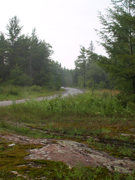
| Description | The northern section of Kawartha Lakes Road 35 (the Victoria Colonization Road) becomes a rough and narrow road through thick forests. After crossing the Head River, it enters the Canadian Shield. |
| Date | |
| Source | Own work |
| Author | Floydian (talk) |
Licensing edit
This file is licensed under the Creative Commons Attribution-Share Alike 3.0 Unported license.
- You are free:
- to share – to copy, distribute and transmit the work
- to remix – to adapt the work
- Under the following conditions:
- attribution – You must give appropriate credit, provide a link to the license, and indicate if changes were made. You may do so in any reasonable manner, but not in any way that suggests the licensor endorses you or your use.
- share alike – If you remix, transform, or build upon the material, you must distribute your contributions under the same or compatible license as the original.
File history
Click on a date/time to view the file as it appeared at that time.
| Date/Time | Thumbnail | Dimensions | User | Comment | |
|---|---|---|---|---|---|
| current | 17:48, 3 August 2010 | | 2,448 × 3,264 (11 MB) | Floydian (talk | contribs) | {{Information |Description=The northern section of Kawartha Lakes Road 35 (the Victoria Colonization Road) becomes a rough and narrow road through thick forests. After crossing the Head River, it enters the Canadian Shield. |Source={{own}} |Date=August 2, |
You cannot overwrite this file.
File usage on Commons
The following page uses this file:
File usage on other wikis
The following other wikis use this file:
- Usage on en.wikipedia.org