File:KMB89D RTMap.png

Size of this preview: 231 × 598 pixels. Other resolutions: 92 × 240 pixels | 185 × 480 pixels | 296 × 768 pixels | 1,251 × 3,240 pixels.
Original file (1,251 × 3,240 pixels, file size: 696 KB, MIME type: image/png)
Captions
Captions
Add a one-line explanation of what this file represents
Summary edit
| Description |
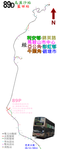
中文(繁體):九巴89D線的走線圖 |
| Date | |
| Source | Own work |
| Author | ATR50 |
Licensing edit
I, the copyright holder of this work, hereby publish it under the following license:
This file is licensed under the Creative Commons Attribution-Share Alike 3.0 Unported license.
- You are free:
- to share – to copy, distribute and transmit the work
- to remix – to adapt the work
- Under the following conditions:
- attribution – You must give appropriate credit, provide a link to the license, and indicate if changes were made. You may do so in any reasonable manner, but not in any way that suggests the licensor endorses you or your use.
- share alike – If you remix, transform, or build upon the material, you must distribute your contributions under the same or compatible license as the original.
File history
Click on a date/time to view the file as it appeared at that time.
| Date/Time | Thumbnail | Dimensions | User | Comment | |
|---|---|---|---|---|---|
| current | 15:58, 5 January 2017 | 1,251 × 3,240 (696 KB) | ATR50~commonswiki (talk | contribs) | 2017年1月換圖 | |
| 16:08, 14 April 2016 | 1,251 × 3,240 (640 KB) | ATR50~commonswiki (talk | contribs) | 2016年4月改良TITLE | ||
| 02:43, 26 November 2014 | 1,251 × 3,240 (664 KB) | ATR50~commonswiki (talk | contribs) | 新加89P線的走線資訊 | ||
| 15:58, 31 March 2014 | 1,251 × 3,240 (597 KB) | ATR50~commonswiki (talk | contribs) | User created page with UploadWizard |
You cannot overwrite this file.
File usage on Commons
The following 10 pages use this file:
- User:Chumwa/OgreBot/Potential transport maps/2016 April 11-20
- User:Chumwa/OgreBot/Potential transport maps/2017 January 1-10
- User:Chumwa/OgreBot/Public transport information/2016 April 11-20
- User:Chumwa/OgreBot/Public transport information/2017 January 1-10
- User:Chumwa/OgreBot/Transport Maps/2016 April 11-20
- User:Chumwa/OgreBot/Transport Maps/2017 January 1-10
- User:Chumwa/OgreBot/Travel and communication maps/2016 April 11-20
- User:Chumwa/OgreBot/Travel and communication maps/2017 January 1-10
- User:OgreBot/Watercraft/2017 January 5
- User:Pechristener/Bridges/2014 March 21-31
File usage on other wikis
The following other wikis use this file:
- Usage on zh.wikipedia.org