File:KNEL.svg

Size of this PNG preview of this SVG file: 688 × 442 pixels. Other resolutions: 320 × 206 pixels | 640 × 411 pixels | 1,024 × 658 pixels | 1,280 × 822 pixels | 2,560 × 1,645 pixels.
Original file (SVG file, nominally 688 × 442 pixels, file size: 261 KB)
Captions
Captions
Add a one-line explanation of what this file represents
Summary edit
| Description |
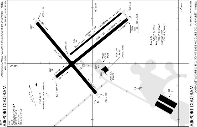
English: FAA diagram for Lakehurst Maxfield Field in Lakehurst, New Jersey, United States |
| Date | |
| Source | http://aeronav.faa.gov/d-tpp/1512/00223ad.pdf |
| Author | National Aeronautical Charting Office (NACO), a department of the Federal Aviation Administration (FAA). |
Licensing edit
This image or file is a work of a Federal Aviation Administration employee, taken or made as part of that person's official duties. As a work of the U.S. federal government, the image is in the public domain in the United States.
|
 |
File history
Click on a date/time to view the file as it appeared at that time.
| Date/Time | Thumbnail | Dimensions | User | Comment | |
|---|---|---|---|---|---|
| current | 14:11, 22 November 2015 | | 688 × 442 (261 KB) | Kopiersperre (talk | contribs) | {{Information |Description={{en|FAA diagram for Lakehurst Maxfield Field in Lakehurst, New Jersey, United States}} |Source=http://aeronav.faa.gov/d-tpp/1512/00223ad.pdf |Date={{subst:CURRENTYEAR}}-{{subst:CURRENTMONTH}}-12 |Author=National Aeronautical... |
You cannot overwrite this file.
File usage on Commons
The following 3 pages use this file: