File:KTM Fiktivni Mereni Vysky.png
Size of this preview: 350 × 599 pixels. Other resolutions: 140 × 240 pixels | 280 × 480 pixels | 877 × 1,500 pixels.
Original file (877 × 1,500 pixels, file size: 1.26 MB, MIME type: image/png)
Captions
Captions
Add a one-line explanation of what this file represents
Summary edit
| Description |
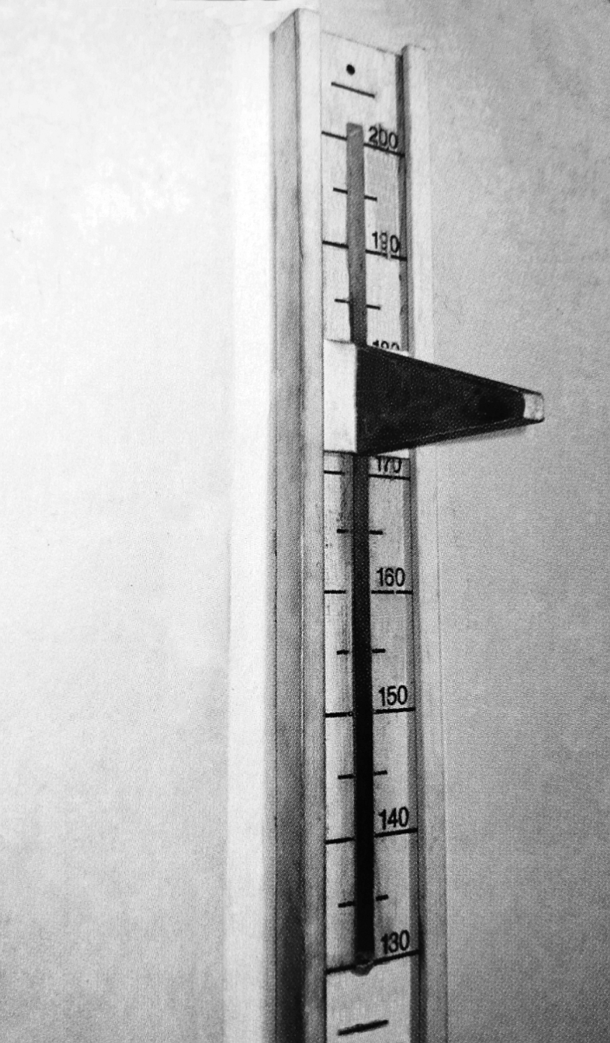
Čeština: Široká dřevěná lišta s namalovanými číselnými údaji možných tělesných výšek, posuvným lichoběžníkovým jezdcem a úzkou vyfrézovanou štěrbinou. Fiktivní „lékařské zařízení k měření tělesné výšky“ vězňů instalované v odstřelovacím koutě (Genickschussecke) bunkru v koncentračním táboře Mauthausen za druhé světové války. Někdy bylo zařízení zahaleno černou látkou takže připomínalo „fotografický přístroj“. Za stěnou, na druhé straně tohoto „výškoměrného přístroje“ byl připraven kat, který popravovanou osobu zastřelil výstřelem do týla z pistole skrze štěrbinu v okamžiku, kdy se osoba ve druhé místnosti otočila zády k přístroji visícím na stěně.
English: A wide wooden bar with painted numbers of possible body heights, a sliding trapezoidal slider and a narrow milled slot. A fictitious "medical height measuring device" for prisoners installed in the sniper's corner (Genickschussecke) of the bunker at the Mauthausen concentration camp during World War II. Sometimes the device was covered with a black cloth so that it resembled a "photographic device". Behind the wall, on the other side of this "altimeter apparatus", an executioner was ready to shoot the executed person in the back of the head with a pistol shot through a slit at the moment when the person in the other room turned his back to the apparatus hanging on the wall. |
| Date | before 1946 |
| Source |
|
| Author |
|
| Camera location | | View this and other nearby images on: OpenStreetMap |
|---|
Licensing edit
This image (or other media file) is in the public domain because its copyright has expired and its author is anonymous.
This applies to the European Union and those countries with a copyright term of 70 years after the work was made available to the public and the author never disclosed their identity. Important: Always mention where the image comes from, as far as possible, and make sure the author never claimed authorship. |
 | |
 |
Note: In Germany and possibly other countries, certain anonymous works published before July 1, 1995 are copyrighted until 70 years after the death of the author. See Übergangsrecht. Please use this template only if the author never claimed authorship or their authorship never became public in any other way. If the work is anonymous or pseudonymous (e.g., published only under a corporate or organization's name), use this template for images published more than 70 years ago.
For a work made available to the public in the United Kingdom, please use Template:PD-UK-unknown instead.
|
File history
Click on a date/time to view the file as it appeared at that time.
| Date/Time | Thumbnail | Dimensions | User | Comment | |
|---|---|---|---|---|---|
| current | 19:23, 28 February 2023 | | 877 × 1,500 (1.26 MB) | Mojmir Churavy (talk | contribs) | Uploaded a work by * {{Unknown photographer |1= }} * CZ: Autorem této fotografie je neznámá osoba. * EN: Author of this photo is unknown person. from * CZ: Fotografický archiv historika a badatele Jaroslava Čvančary * EN: Photographic archive of historian and researcher Jaroslav Čvančara with UploadWizard |
You cannot overwrite this file.
File usage on Commons
The following page uses this file:
File usage on other wikis
The following other wikis use this file:
- Usage on cs.wikipedia.org