File:KVB Linien 3 4 5 13 16 18.svg

Size of this PNG preview of this SVG file: 657 × 600 pixels. Other resolutions: 263 × 240 pixels | 526 × 480 pixels | 841 × 768 pixels | 1,122 × 1,024 pixels | 2,244 × 2,048 pixels | 1,227 × 1,120 pixels.
Original file (SVG file, nominally 1,227 × 1,120 pixels, file size: 150 KB)
Captions
Captions
Add a one-line explanation of what this file represents
Summary edit
| Description |
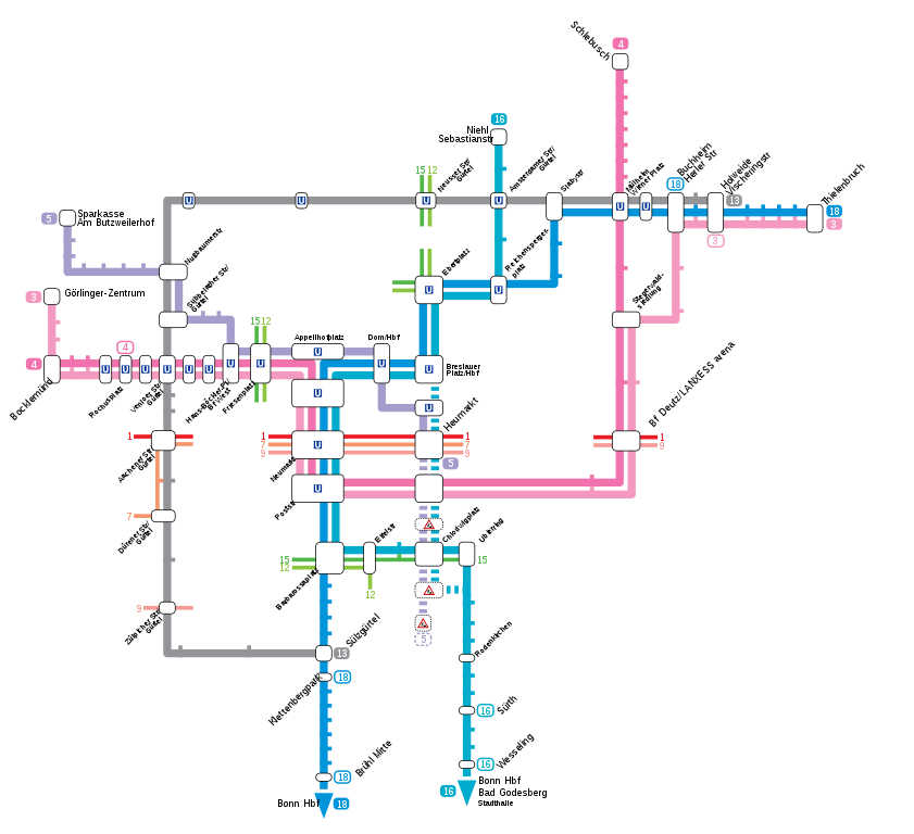
Deutsch: Netzkarte KVB-Linien 3, 4, 5, 13, 16 & 18 |
| Date | |
| Source | Own work (own drawing) |
| Author | Qualle |
Licensing edit
| I, the copyright holder of this work, release this work into the public domain. This applies worldwide. In some countries this may not be legally possible; if so: I grant anyone the right to use this work for any purpose, without any conditions, unless such conditions are required by law. |
File history
Click on a date/time to view the file as it appeared at that time.
| Date/Time | Thumbnail | Dimensions | User | Comment | |
|---|---|---|---|---|---|
| current | 16:13, 15 December 2019 | | 1,227 × 1,120 (150 KB) | Raymond (talk | contribs) | Umbenennung Haltestelle Äußere Kanalstraße -> Rochusplatz |
| 06:35, 27 September 2018 |  | 1,227 × 1,120 (149 KB) | Raymond (talk | contribs) | fix Görlinger-Zentrum | |
| 06:43, 30 August 2018 |  | 1,227 × 1,120 (149 KB) | Raymond (talk | contribs) | Update Linie 3 im Westen ab/bis Görlinger-Zentrum | |
| 20:28, 18 November 2014 |  | 1,150 × 1,050 (150 KB) | Faxel (talk | contribs) | Linie 5 bis Heumarkt; kleine Angleichungen | |
| 10:25, 9 December 2012 |  | 1,150 × 1,050 (153 KB) | Qualle (talk | contribs) | 5 Rathaus | |
| 08:59, 21 August 2011 |  | 1,150 × 1,050 (161 KB) | Qualle (talk | contribs) | Minor tweaks | |
| 10:11, 12 December 2010 |  | 1,150 × 1,050 (162 KB) | Qualle (talk | contribs) | Bitsteam Vera | |
| 09:50, 12 December 2010 |  | 1,150 × 1,050 (161 KB) | Qualle (talk | contribs) | Line 5 verlängert | |
| 09:29, 28 August 2007 |  | 1,150 × 1,050 (162 KB) | Qualle (talk | contribs) | {{Information |Description={{de|Netzkarte KVB-Linien 3, 4, 5, 13, 16 & 18}} |Source=own drawing |Date=2007-08-28 |Author=Qualle |Permission= |other_versions= }} Category:Public transport maps of Cologne |
You cannot overwrite this file.
File usage on Commons
The following 15 pages use this file:
- User:Chumwa/OgreBot/Potential transport maps/2018 August 21-31
- User:Chumwa/OgreBot/Potential transport maps/2018 September 21-30
- User:Chumwa/OgreBot/Potential transport maps/2019 December 11-20
- User:Chumwa/OgreBot/Public transport information/2018 August 21-31
- User:Chumwa/OgreBot/Public transport information/2018 September 21-30
- User:Chumwa/OgreBot/Public transport information/2019 December 11-20
- User:Chumwa/OgreBot/Transport Maps/2018 August 21-31
- User:Chumwa/OgreBot/Transport Maps/2018 September 21-30
- User:Chumwa/OgreBot/Transport Maps/2019 December 11-20
- User:Chumwa/OgreBot/Travel and communication maps/2018 August 21-31
- User:Chumwa/OgreBot/Travel and communication maps/2018 September 21-30
- User:Clic/Nahverkehr in Deutschland/2019 December 11-20
- User:Nordlicht8/Rail Germany/2018 August 21-31
- User:Nordlicht8/Rail Germany/2018 September 21-30
- User:Nordlicht8/Rail Germany/2019 December 11-20
File usage on other wikis
The following other wikis use this file:
- Usage on cs.wikipedia.org
- Usage on de.wikipedia.org
- Usage on ja.wikipedia.org
- Usage on uk.wikipedia.org