File:Kaart boshuijserpolder 1652.jpg
No higher resolution available.
Kaart_boshuijserpolder_1652.jpg (350 × 281 pixels, file size: 41 KB, MIME type: image/jpeg)
Captions
Captions
Add a one-line explanation of what this file represents
Summary edit
| Description |
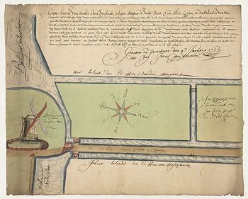
Nederlands: Kaart van landerijen buiten de Wittepoort bij de Boshuijser watermolen. (Met afbeelding van de molen). Gelegen circa aan de huidige Toussaintkade, bij de Genestetstraat, tussen Toussaintkade en Kneppelhoutstraat. Tekening in kleur. |
| Date | |
| Source | Beeldbank Regionaal Archief Leiden. Transferred from nl.wikipedia to Commons. |
| Author | Unknown author |
Licensing edit
|
This work is in the public domain in its country of origin and other countries and areas where the copyright term is the author's life plus 100 years or fewer. | |
| This file has been identified as being free of known restrictions under copyright law, including all related and neighboring rights. | |
Original upload log edit
The original description page was here. All following user names refer to nl.wikipedia.
- 2009-05-29 20:39 Bmulckhu 350×281× (42129 bytes) {{Information |Description= Kaart van landerijen buiten de Wittepoort bij de Boshuijser watermolen. (Met afbeelding van de molen). Gelegen circa aan de huidige Toussaintkade, bij de Genestetstraat, tussen Toussaintkade en Kneppelhoutstraat. Tekening in k
File history
Click on a date/time to view the file as it appeared at that time.
| Date/Time | Thumbnail | Dimensions | User | Comment | |
|---|---|---|---|---|---|
| current | 15:42, 31 May 2009 | | 350 × 281 (41 KB) | BotMultichill (talk | contribs) | {{BotMoveToCommons|nl.wikipedia|year={{subst:CURRENTYEAR}}|month={{subst:CURRENTMONTHNAME}}|day={{subst:CURRENTDAY}}}} {{Information |Description={{nl|Kaart van landerijen buiten de Wittepoort bij de Boshuijser watermolen. (Met afbeelding van de molen). |
You cannot overwrite this file.
File usage on Commons
There are no pages that use this file.
File usage on other wikis
The following other wikis use this file:
- Usage on nl.wikipedia.org