File:Kagoshima prefecture Electoral district map.svg

Size of this PNG preview of this SVG file: 305 × 600 pixels. Other resolutions: 122 × 240 pixels | 244 × 480 pixels | 390 × 768 pixels | 520 × 1,024 pixels | 1,041 × 2,048 pixels | 395 × 777 pixels.
Original file (SVG file, nominally 395 × 777 pixels, file size: 29 KB)
Captions
Captions
Add a one-line explanation of what this file represents
Summary
edit
|
This file may be updated to reflect new information. If you wish to use a specific version of the file without it being overwritten, please upload the required version as a separate file. |
| Description |
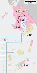
日本語:衆議院小選挙区制選挙区の鹿児島県における区割り。赤線は同一市町村内を通る選挙区境界。水色は海上または湖沼上での境界。 |
||
| Date | |||
| Source | 元の市町村地図はja:ファイル:包括自治体区画図 46000.svgを使用。 | ||
| Author | Sakoppi | ||
| Permission (Reusing this file) |
This file is licensed under the Creative Commons Attribution-Share Alike 3.0 Unported license.
You may select the license of your choice. |

Any autoconfirmed user can overwrite this file from the same source. Please ensure that overwrites comply with the guideline.
File history
Click on a date/time to view the file as it appeared at that time.
| Date/Time | Thumbnail | Dimensions | User | Comment | |
|---|---|---|---|---|---|
| current | 17:38, 4 January 2023 | | 395 × 777 (29 KB) | そらみみ (talk | contribs) | 細部変更 |
| 17:37, 4 January 2023 |  | 395 × 777 (29 KB) | そらみみ (talk | contribs) | 線の円滑化 | |
| 08:10, 2 October 2020 |  | 395 × 777 (29 KB) | そらみみ (talk | contribs) | 谷山の境界線修正 | |
| 21:17, 16 July 2017 |  | 395 × 777 (29 KB) | そらみみ (talk | contribs) | Update. | |
| 21:17, 16 July 2017 |  | 395 × 777 (29 KB) | そらみみ (talk | contribs) | Update. | |
| 15:20, 18 May 2017 |  | 395 × 777 (36 KB) | そらみみ (talk | contribs) | 文字を修正 | |
| 14:39, 12 April 2017 |  | 395 × 777 (32 KB) | そらみみ (talk | contribs) | 細部を修正 | |
| 13:06, 31 March 2017 |  | 395 × 777 (32 KB) | そらみみ (talk | contribs) | 海上の線を水色に変更 | |
| 14:36, 10 September 2012 |  | 395 × 777 (34 KB) | Sakoppi (talk | contribs) | 太くし過ぎたので少し細く・・・ | |
| 14:31, 10 September 2012 |  | 395 × 777 (34 KB) | Sakoppi (talk | contribs) | 線を太めに変更 |
You cannot overwrite this file.
File usage on Commons
The following 5 pages use this file:
File usage on other wikis
The following other wikis use this file:
- Usage on en.wikipedia.org
- Usage on fr.wikipedia.org
- Usage on ja.wikipedia.org
- Usage on ko.wikipedia.org
- Usage on vi.wikipedia.org
- Usage on zh.wikipedia.org