File:KarenNov141962TIROS.gif

Size of this preview: 649 × 599 pixels. Other resolutions: 260 × 240 pixels | 520 × 480 pixels | 706 × 652 pixels.
Original file (706 × 652 pixels, file size: 171 KB, MIME type: image/gif)
Captions
Captions
Add a one-line explanation of what this file represents
Summary edit
| Description |
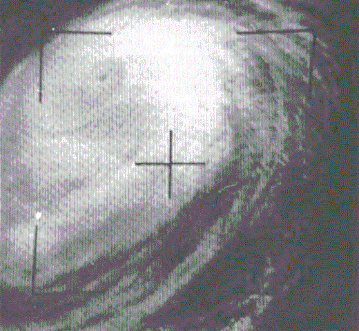
English: This TIROS weather satellite image of Typhoon Karen was taken on November 14, 1962 |
| Date | |
| Source | Mariners Weather Log, January 1963, pg. 34 |
| Author | United States Weather Bureau |
| Camera location | | View this and other nearby images on: OpenStreetMap |
|---|
Licensing edit
This work is in the public domain in the United States because it is a work prepared by an officer or employee of the United States Government as part of that person’s official duties under the terms of Title 17, Chapter 1, Section 105 of the US Code.
Note: This only applies to original works of the Federal Government and not to the work of any individual U.S. state, territory, commonwealth, county, municipality, or any other subdivision. This template also does not apply to postage stamp designs published by the United States Postal Service since 1978. (See § 313.6(C)(1) of Compendium of U.S. Copyright Office Practices). It also does not apply to certain US coins; see The US Mint Terms of Use.
|
 | |
| This file has been identified as being free of known restrictions under copyright law, including all related and neighboring rights. | ||
File history
Click on a date/time to view the file as it appeared at that time.
| Date/Time | Thumbnail | Dimensions | User | Comment | |
|---|---|---|---|---|---|
| current | 03:35, 25 July 2021 | | 706 × 652 (171 KB) | Davadeco (talk | contribs) | Reverted to version as of 07:43, 1 July 2016 (UTC) |
| 03:28, 25 July 2021 |  | 1,896 × 2,034 (2.24 MB) | Davadeco (talk | contribs) | better | |
| 07:43, 1 July 2016 |  | 706 × 652 (171 KB) | Talingcat (talk | contribs) | better | |
| 00:58, 27 March 2013 |  | 1,896 × 2,034 (1.93 MB) | Thegreatdr (talk | contribs) | User created page with UploadWizard |
You cannot overwrite this file.
File usage on Commons
The following 2 pages use this file:
File usage on other wikis
The following other wikis use this file:
- Usage on en.wikipedia.org
- Usage on ja.wikipedia.org
- Usage on pt.wikipedia.org
- Usage on www.wikidata.org
- Usage on zh.wikipedia.org