File:Karte A Tirol IL.svg

Size of this PNG preview of this SVG file: 800 × 457 pixels. Other resolutions: 320 × 183 pixels | 640 × 366 pixels | 1,024 × 585 pixels | 1,280 × 731 pixels | 2,560 × 1,463 pixels.
Original file (SVG file, nominally 1,050 × 600 pixels, file size: 16 KB)
Captions
Captions
Add a one-line explanation of what this file represents
Summary edit
| Description |
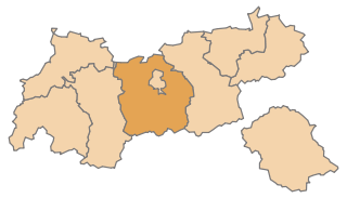
English: Map of the Austrian State Tyrol, highlighting Innsbruck Land
Deutsch: Karte des österreichischen Bundeslandes Tirol, Innsbruck Land hervorgehoben |
| Date | |
| Source | Own work |
| Author | AleXXw |
| SVG development |
Licensing edit
| I, the copyright holder of this work, release this work into the public domain. This applies worldwide. In some countries this may not be legally possible; if so: I grant anyone the right to use this work for any purpose, without any conditions, unless such conditions are required by law. |
File history
Click on a date/time to view the file as it appeared at that time.
| Date/Time | Thumbnail | Dimensions | User | Comment | |
|---|---|---|---|---|---|
| current | 12:56, 10 July 2010 | | 1,050 × 600 (16 KB) | AleXXw (talk | contribs) | == {{int:filedesc}} == {{Information |Description={{en|1=Map of the Austrian State Tyrol, highlighting Innsbruck Land}} {{de|1=Karte des österreichischen Bundeslandes Tirol, Innsbruck Land hervorgehoben}} |Source=Eigenes Werk (own work) |Author=[[User:Al |
You cannot overwrite this file.
File usage on Commons
The following 2 pages use this file:
File usage on other wikis
The following other wikis use this file:
- Usage on de.wikipedia.org
- Hall in Tirol
- Völs (Tirol)
- Rum (Tirol)
- Fulpmes
- Absam
- Wildermieming
- Natters
- Schönberg im Stubaital
- Telfs
- Mutters
- Mieders
- Lans (Tirol)
- Steinach am Brenner
- Matrei am Brenner
- Thaur
- Aldrans
- Ampass
- Sistrans
- Rinn
- Tulfes
- Scharnitz
- Neustift im Stubaital
- Gries am Brenner
- Obernberg am Brenner
- Trins
- Gschnitz
- Vals (Tirol)
- Schmirn
- Gries im Sellrain
- Sellrain
- St. Sigmund im Sellrain
- Leutasch
- Reith bei Seefeld
- Vorlage:Navigationsleiste Städte und Gemeinden im Bezirk Innsbruck-Land
- Telfes im Stubai
- Axams
- Hatting
- Axamer Lizum
- Wattens
- Zirl
- Polling in Tirol
- Birgitz
- Götzens
- Grinzens
- Patsch (Tirol)
- Ellbögen
- Navis (Tirol)
- Kematen in Tirol
- Oberperfuss
- Unterperfuss
View more global usage of this file.