File:Karte Dresdner Heide.png

Size of this preview: 800 × 485 pixels. Other resolutions: 320 × 194 pixels | 640 × 388 pixels | 1,024 × 621 pixels | 1,535 × 931 pixels.
Original file (1,535 × 931 pixels, file size: 1.09 MB, MIME type: image/png)
Captions
Captions
Add a one-line explanation of what this file represents
Summary edit
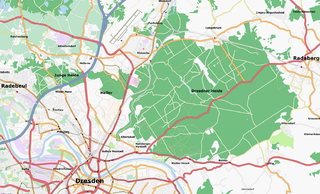
| Description | Map of the Dresdner Heide and the northern parts of Dresden |
| Date | |
| Source | Map based on openstreetmap.org base layer, some location labeling by myself |
| Author | Geo-Loge |
| Permission (Reusing this file) |
openstreetmap.org is published under Creative Commons Attribution-Share Alike 2.0 |
Licensing edit
I, the copyright holder of this work, hereby publish it under the following licenses:

|
Permission is granted to copy, distribute and/or modify this document under the terms of the GNU Free Documentation License, Version 1.2 or any later version published by the Free Software Foundation; with no Invariant Sections, no Front-Cover Texts, and no Back-Cover Texts. A copy of the license is included in the section entitled GNU Free Documentation License. |
| This file is licensed under the Creative Commons Attribution-Share Alike 3.0 Unported license. | ||
| ||
| This licensing tag was added to this file as part of the GFDL licensing update. |
This file is licensed under the Creative Commons Attribution-Share Alike 2.5 Generic, 2.0 Generic and 1.0 Generic license.
- You are free:
- to share – to copy, distribute and transmit the work
- to remix – to adapt the work
- Under the following conditions:
- attribution – You must give appropriate credit, provide a link to the license, and indicate if changes were made. You may do so in any reasonable manner, but not in any way that suggests the licensor endorses you or your use.
- share alike – If you remix, transform, or build upon the material, you must distribute your contributions under the same or compatible license as the original.
You may select the license of your choice.
File history
Click on a date/time to view the file as it appeared at that time.
| Date/Time | Thumbnail | Dimensions | User | Comment | |
|---|---|---|---|---|---|
| current | 18:14, 9 January 2008 | | 1,535 × 931 (1.09 MB) | Geo-Loge~commonswiki (talk | contribs) | {{Information |Description=Map of the Dresdner Heide and the northern parts of Dresden |Source=Map based on http://www.openstreetmap.org/ openstreetmap.org base layer, some location labeling by myself |Date=09 January 2008 |Author=[[User:Geo-Loge|Geo- |
You cannot overwrite this file.
File usage on Commons
There are no pages that use this file.
File usage on other wikis
The following other wikis use this file:
- Usage on de.wikipedia.org
- Usage on en.wikipedia.org