File:Karte Insel Usedom (Swinemünde).png
Size of this preview: 800 × 497 pixels. Other resolutions: 320 × 199 pixels | 640 × 397 pixels | 810 × 503 pixels.
Original file (810 × 503 pixels, file size: 272 KB, MIME type: image/png)
Captions
Captions
Add a one-line explanation of what this file represents

|
This map image could be re-created using vector graphics as an SVG file. This has several advantages; see Commons:Media for cleanup for more information. If an SVG form of this image is available, please upload it and afterwards replace this template with
{{vector version available|new image name}}.
It is recommended to name the SVG file “Karte Insel Usedom (Swinemünde).svg”—then the template Vector version available (or Vva) does not need the new image name parameter. |
Summary edit
| Description |
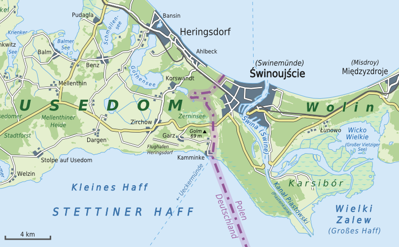
Deutsch: Karte von der Insel Usedom mit den wichtigsten Gemeinden
English: Map of Usedom Island with its most important municipalities |
| Date | |
| Source |
Own work |
| Author | Alexrk2 |
| Other versions |

.png&action=edit§ion=1)

|
This map has been made or improved in the German Kartenwerkstatt (Map Lab). You can propose maps to improve as well.
|
Licensing edit
.png&action=edit§ion=2)
I, the copyright holder of this work, hereby publish it under the following license:
This file is licensed under the Creative Commons Attribution-Share Alike 3.0 Unported license.
- You are free:
- to share – to copy, distribute and transmit the work
- to remix – to adapt the work
- Under the following conditions:
- attribution – You must give appropriate credit, provide a link to the license, and indicate if changes were made. You may do so in any reasonable manner, but not in any way that suggests the licensor endorses you or your use.
- share alike – If you remix, transform, or build upon the material, you must distribute your contributions under the same or compatible license as the original.
File history
Click on a date/time to view the file as it appeared at that time.
| Date/Time | Thumbnail | Dimensions | User | Comment | |
|---|---|---|---|---|---|
| current | 21:09, 2 April 2022 | | 810 × 503 (272 KB) | Andrew J.Kurbiko (talk | contribs) | File:Karte Insel Usedom.png cropped 30 % horizontally, 52 % vertically using CropTool with precise mode. |
You cannot overwrite this file.
File usage on Commons
The following page uses this file:
File usage on other wikis
The following other wikis use this file:
- Usage on en.wikipedia.org
- Usage on fa.wikipedia.org
.png&oldid=646195028)