File:Karte Odenwaldbahn.jpg
Size of this preview: 395 × 600 pixels. Other resolutions: 158 × 240 pixels | 316 × 480 pixels | 506 × 768 pixels | 674 × 1,024 pixels | 1,348 × 2,048 pixels | 2,908 × 4,416 pixels.
Original file (2,908 × 4,416 pixels, file size: 813 KB, MIME type: image/jpeg)
Captions
Captions
Add a one-line explanation of what this file represents
Summary edit

|
This transport map image could be re-created using vector graphics as an SVG file. This has several advantages; see Commons:Media for cleanup for more information. If an SVG form of this image is available, please upload it and afterwards replace this template with
{{vector version available|new image name}}.
It is recommended to name the SVG file “Karte Odenwaldbahn.svg”—then the template Vector version available (or Vva) does not need the new image name parameter. |

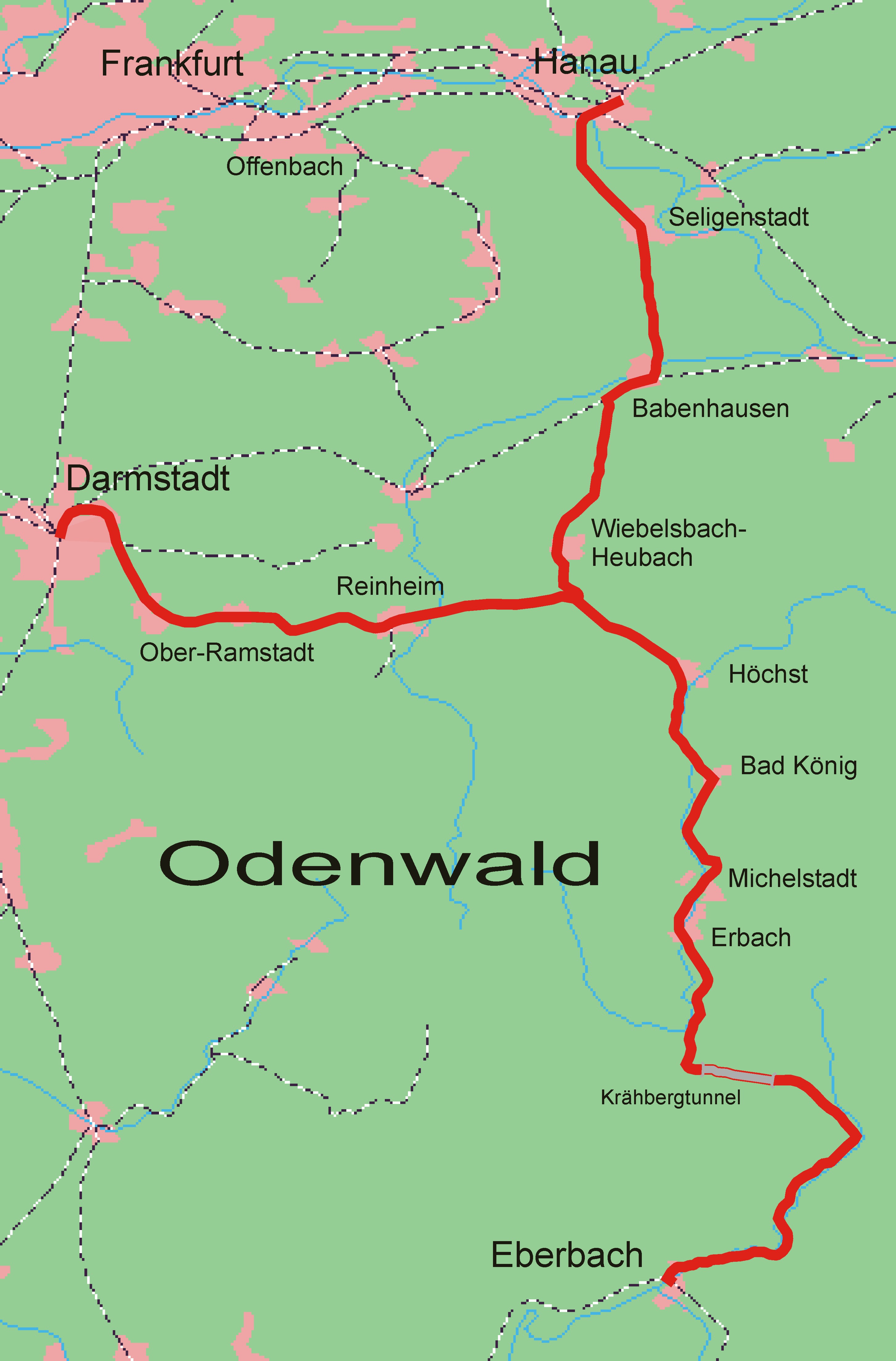
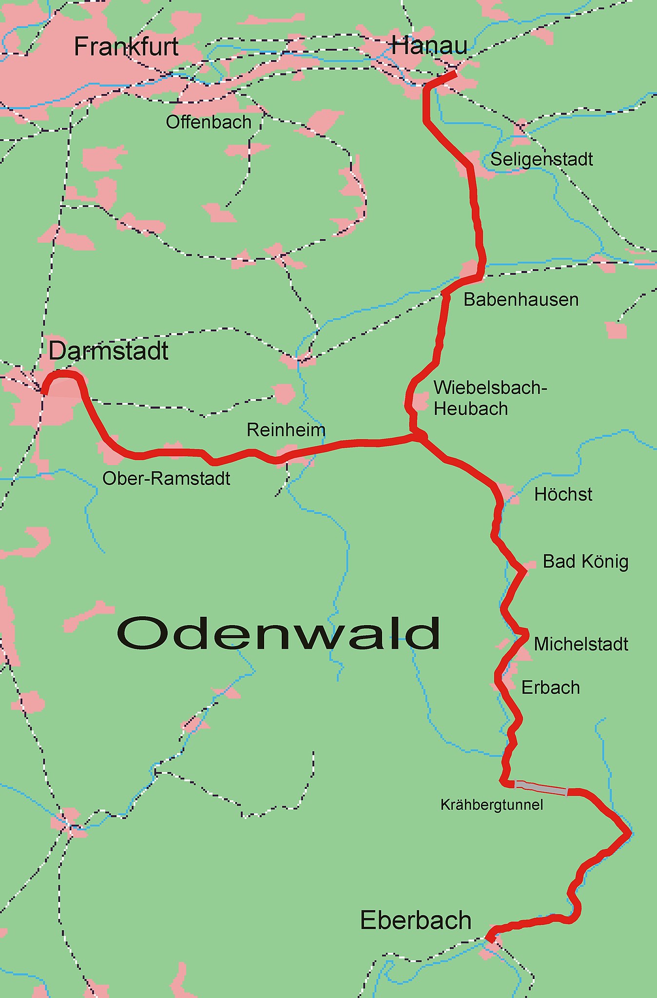
| Description | Karte des Verlaufes der de:Odenwaldbahn, Kartenquelle: [1] |
| Date | 18 March 2005 (original upload date) |
| Source | Originally from de.wikipedia; description page is/was here. |
| Author |
The original uploader was Markus Schweiß at German Wikipedia. Later versions were uploaded by Presse03 at de.wikipedia. |
Licensing edit

|
Permission is granted to copy, distribute and/or modify this document under the terms of the GNU Free Documentation License, Version 1.2 or any later version published by the Free Software Foundation; with no Invariant Sections, no Front-Cover Texts, and no Back-Cover Texts. A copy of the license is included in the section entitled GNU Free Documentation License. |
| This file is licensed under the Creative Commons Attribution-Share Alike 3.0 Unported license. | ||
| ||
| This licensing tag was added to this file as part of the GFDL licensing update. |
Original upload log edit
(All user names refer to de.wikipedia)
- 2005-08-01 13:27 Presse03 2908×4416×8 (832890 bytes)
- 2005-08-01 11:04 Presse03 2908×4416×8 (820810 bytes)
- 2005-03-18 19:05 Markus Schweiß 750×726×8 (100676 bytes) Karte des Verlaufes der [[Odenwaldbahn]], Kartenquelle: [http://www.demis.nl/mapserver/mapper.asp] {{Bild-GFDL}}
File history
Click on a date/time to view the file as it appeared at that time.
| Date/Time | Thumbnail | Dimensions | User | Comment | |
|---|---|---|---|---|---|
| current | 14:05, 20 March 2007 | | 2,908 × 4,416 (813 KB) | Presse03 (talk | contribs) | {{Information |Description=Karte des Verlaufes der de:Odenwaldbahn, Kartenquelle: [http://www.demis.nl/mapserver/mapper.asp] |Source=Originally from [http://de.wikipedia.org de.wikipedia]; description page is/was [http://de.wikipedia.org/w/index.php? |
You cannot overwrite this file.
File usage on Commons
The following page uses this file:
File usage on other wikis
The following other wikis use this file:
- Usage on de.wikipedia.org
- Usage on en.wikipedia.org
- Usage on www.wikidata.org