File:Karte Ruhr, Niedernhofen, Herdecke.jpg

Size of this preview: 800 × 548 pixels. Other resolutions: 320 × 219 pixels | 640 × 439 pixels | 1,024 × 702 pixels | 1,211 × 830 pixels.
Original file (1,211 × 830 pixels, file size: 297 KB, MIME type: image/jpeg)
Captions
Captions
Add a one-line explanation of what this file represents
Summary edit
| Description |
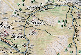
Deutsch: Karte von dem Ruhrstrom, 1735. Verfertigt von Konrad Henning, Regierung Düsseldorf, Wasserbauplankammer. Zu sehen die Ruhrschleife mit Haus Niedernhofen, Hengstey, Schiffwinkel und Herdecke. Rechts die Lennemündung. |
| Date | |
| Source | Landesarchiv NRW Abteilung Rheinland – DFG-Viewer RW Karten, Nr. 3792 |
| Author | Konrad Henning |
Licensing edit
|
This work is in the public domain in its country of origin and other countries and areas where the copyright term is the author's life plus 100 years or fewer. This work is in the public domain in the United States because it was published (or registered with the U.S. Copyright Office) before January 1, 1929. | |
| This file has been identified as being free of known restrictions under copyright law, including all related and neighboring rights. | |
File history
Click on a date/time to view the file as it appeared at that time.
| Date/Time | Thumbnail | Dimensions | User | Comment | |
|---|---|---|---|---|---|
| current | 13:37, 10 January 2021 | | 1,211 × 830 (297 KB) | Bärwinkel,Klaus (talk | contribs) | {{Information |Description={{de|1=Karte von dem Ruhrstrom, 1735. Verfertigt von Konrad Henning, Regierung Düsseldorf, Wasserbauplankammer. Zu sehen die Ruhrschleife zwischen Lenne, Haus Niedernhofen, Hengstey, Schiffwinkel und Herdecke.}} |Source=Landesarchiv NRW Abteilung Rheinland – DFG-Viewer RW Karten, Nr. 3792 |Date=1735 |Author=Konrad Henning |Permission= |other_versions= }} == {{int:license}} == {{free screensh... |
You cannot overwrite this file.
File usage on Commons
The following page uses this file:
File usage on other wikis
The following other wikis use this file:
- Usage on de.wikipedia.org