File:Karte Südbahn in Wuerttemberg 1854.png

Size of this preview: 435 × 599 pixels. Other resolutions: 174 × 240 pixels | 348 × 480 pixels | 557 × 768 pixels | 743 × 1,024 pixels | 2,000 × 2,756 pixels.
Original file (2,000 × 2,756 pixels, file size: 967 KB, MIME type: image/png)
Captions
Captions
Add a one-line explanation of what this file represents
Summary edit
| Description |
|
| Date | |
| Source | Own work |
| Author | K. Jähne |
Licensing edit
| This work is ineligible for copyright and therefore in the public domain because it consists entirely of information that is common property and contains no original authorship. |
File history
Click on a date/time to view the file as it appeared at that time.
| Date/Time | Thumbnail | Dimensions | User | Comment | |
|---|---|---|---|---|---|
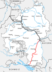
| current | 20:32, 17 November 2013 | | 2,000 × 2,756 (967 KB) | Kjunix (talk | contribs) | == {{int:filedesc}} == {{Information| |Description = *{{de|Karte des württembergischen Eisenbahnstreckennetzes, Stand 1954. Rot markiert: Südbahn (Ulm–Friedrichshafen).}} |Source = {{Own}} |Date = 2013-11-17 |Author = K. Jähne |Permission = }} =... |
You cannot overwrite this file.
File usage on Commons
The following page uses this file:
File usage on other wikis
The following other wikis use this file:
- Usage on de.wikipedia.org
- Usage on pl.wikipedia.org