File:Karte Straßenbahnnetz Hannover 1920 and 1957.svg

Size of this PNG preview of this SVG file: 637 × 600 pixels. Other resolutions: 255 × 240 pixels | 510 × 480 pixels | 815 × 768 pixels | 1,087 × 1,024 pixels | 2,174 × 2,048 pixels | 2,477 × 2,333 pixels.
Original file (SVG file, nominally 2,477 × 2,333 pixels, file size: 75 KB)
Captions
Captions
Add a one-line explanation of what this file represents
Summary edit
| Description |
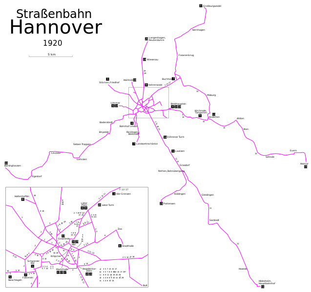
Deutsch: Karte der Straßenbahn Hannover im Jahr 1920 und 1957 |
| Date | (in visible layers) and 1957 (in hidden layers) |
| Source | Own work, using this map by Voogd075 |
| Author | Maximilian Dörrbecker (Chumwa) |
| Permission (Reusing this file) |
I, the copyright holder of this work, hereby publish it under the following license: This file is licensed under the Creative Commons Attribution-Share Alike 2.5 Generic license.
Sie dürfen das Bild zu den folgenden Bedingungen nutzen:
|
| Other versions |


File history
Click on a date/time to view the file as it appeared at that time.
| Date/Time | Thumbnail | Dimensions | User | Comment | |
|---|---|---|---|---|---|
| current | 18:21, 26 March 2014 | | 2,477 × 2,333 (75 KB) | Chumwa (talk | contribs) | == {{int:filedesc}} == {{Information | Description = {{de|1=Karte der Straßenbahn Hannover im Jahr 1920 und 1957}} |Source = {{own}}, using this map by {{U|Voogd075}} |Date = 1920 (in visible layers... |
You cannot overwrite this file.
File usage on Commons
The following 7 pages use this file: