File:Karte Tessiner Alpen.png

Size of this preview: 563 × 600 pixels. Other resolutions: 225 × 240 pixels | 451 × 480 pixels | 721 × 768 pixels | 961 × 1,024 pixels | 1,923 × 2,048 pixels | 2,855 × 3,041 pixels.
Original file (2,855 × 3,041 pixels, file size: 3.21 MB, MIME type: image/png)
File information
Structured data
Captions
Captions
Add a one-line explanation of what this file represents
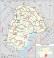
Tessiner Alpen in den Westalpen.
Summary edit
| DescriptionKarte Tessiner Alpen.png |
Deutsch: Lagekarte der Tessiner Alpen. Umrahmt vom Fluss Tessin (Ticino) im Norden und Osten und dem Lago Maggiore im Süden, den dieser Fluss durchfliesst, zeigt die Commons-Karte die Berggruppen der Tessiner Alpen und Täler wie das Verzascatal mit dem Pizzo di Vogorno, dem Monte Zucchero oder das Centovalli. Im Westen der Fluss Toce, der von den Gipfeln um den Basòdino im Norden durch mehrere Täler ebenfalls in den Lago Maggiore fliesst, genaugenommen also ein indirekter Nebenfluss des Ticino. Städte und Dörfer am Rand des Gebirges: Bellinzona, Biasca, Domodossola, Formazza, Locarno und Verbania am Lago Maggiore. English: Map of Ticino river alps (Tessiner Alpen) with Lake Maggiore and Toce river in South and West. Basòdino, Monte Zucchero and other mountains. Mountain groups and nearby cities like Bellinzona, Biasca, Domodossola, Locarno, Verbania, or little villages like that in valley Valle Verzasca. |
|||||||||
| Date | ||||||||||
| Source |
Own work Map was created using:
|
|||||||||
| Creator | ||||||||||
| Permission (Reusing this file) |
Map data (c) OpenStreetMap (and) contributors, CC-BY-SA | |||||||||
| Geotemporal data | ||||||||||
| Bounding box |
|
|||||||||
| Georeferencing | View the georeferenced map in the Wikimaps Warper | |||||||||
This file is licensed under the Creative Commons Attribution-Share Alike 2.0 Generic license.
- You are free:
- to share – to copy, distribute and transmit the work
- to remix – to adapt the work
- Under the following conditions:
- attribution – You must give appropriate credit, provide a link to the license, and indicate if changes were made. You may do so in any reasonable manner, but not in any way that suggests the licensor endorses you or your use.
- share alike – If you remix, transform, or build upon the material, you must distribute your contributions under the same or compatible license as the original.

|
This work is licensed under the Open Database License (summary).Open Database LicenseODbLhttp://opendatacommons.org/licenses/odbl/1.0/true |
| Annotations InfoField | This image is annotated: View the annotations at Commons |
File history
Click on a date/time to view the file as it appeared at that time.
| Date/Time | Thumbnail | Dimensions | User | Comment | |
|---|---|---|---|---|---|
| current | 16:38, 1 April 2018 |  | 2,855 × 3,041 (3.21 MB) | Pechristener (talk | contribs) | überzähliger Gipfel entfernt |
| 02:20, 1 April 2018 |  | 2,855 × 3,041 (3.18 MB) | Pechristener (talk | contribs) | shade of grey changed | |
| 01:47, 1 April 2018 |  | 2,855 × 3,041 (3.17 MB) | Pechristener (talk | contribs) | {{Information |Description={{de|1=Lagekarte der Tessiner Alpen}} |Source ={{own}} Map was created using: *[http://www.openstreetmap.org/ Open Street Map] *Switzerland location map.svg for location map |Author = *Pechristener *File:Switzerland location map.svg: NordNordWest |Date =2015-02-12 |Permission =Map data (c) ... |
You cannot overwrite this file.
File usage on Commons
The following 7 pages use this file:
File usage on other wikis
The following other wikis use this file:
- Usage on als.wikipedia.org
- Usage on cs.wikipedia.org
- Usage on de.wikipedia.org
- Tessiner Alpen
- Basòdino
- Capanna Cristallina
- Capanna Grossalp
- Gridone
- Benutzer:FkMohr/Baustelle/Test
- Liste der Gebirgsgruppen in den Westalpen
- Vorlage:Positionskarte Tessiner Alpen
- Passo di Cristallina
- Bocchetta di Val Maggia
- Tamierpass
- Benutzer Diskussion:Pechristener/Alpenkarten
- Pizzo la Scheggia
- Monte Spalavera
- Usage on it.wikipedia.org
- Usage on sk.wikipedia.org
- Usage on zh.wikipedia.org
Metadata
This file contains additional information such as Exif metadata which may have been added by the digital camera, scanner, or software program used to create or digitize it. If the file has been modified from its original state, some details such as the timestamp may not fully reflect those of the original file. The timestamp is only as accurate as the clock in the camera, and it may be completely wrong.
| Horizontal resolution | 78.75 dpc |
|---|---|
| Vertical resolution | 78.75 dpc |
| Software used |