File:Karte der Bahnstrecke Plaue - Themar.png

Size of this preview: 447 × 600 pixels. Other resolutions: 179 × 240 pixels | 358 × 480 pixels | 572 × 768 pixels | 763 × 1,024 pixels | 1,599 × 2,146 pixels.
Original file (1,599 × 2,146 pixels, file size: 1.58 MB, MIME type: image/png)
Captions
Captions
Add a one-line explanation of what this file represents
Summary edit
| Description |
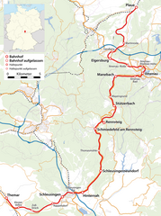
Deutsch: Karte der Bahnstrecke Plaue – ThemaR |
| Date | see file history |
| Source |
Own work, using
|
| Creator | |
| Permission (Reusing this file) |
All OpenStreetMap data and maps are Creative Commons "CC-BY-SA 2.0" licensed This file is licensed under the Creative Commons Attribution-Share Alike 2.0 Generic license.
|
| Georeferencing | If inappropriate please set warp_status = skip to hide. |
File history
Click on a date/time to view the file as it appeared at that time.
| Date/Time | Thumbnail | Dimensions | User | Comment | |
|---|---|---|---|---|---|
| current | 16:04, 16 August 2009 | | 1,599 × 2,146 (1.58 MB) | Chumwa (talk | contribs) | {{Information |Description={{de|Karte der Bahnstrecke Plaue – ThemaR}} |Author=Maximilian Dörrbecker (Chumwa) |Source={own}, using * OpenStreetMap data for the background * [[:File:Germany_location_map.svg|th |
You cannot overwrite this file.
File usage on Commons
The following 2 pages use this file:
File usage on other wikis
The following other wikis use this file:
- Usage on de.wikipedia.org
- Usage on en.wikipedia.org
- Usage on hu.wikipedia.org
- Usage on pl.wikipedia.org
- Usage on www.wikidata.org