File:Karte der Terroranschläge vom 13. November 2015 in Paris - Copy.jpg

Size of this preview: 588 × 599 pixels. Other resolutions: 236 × 240 pixels | 471 × 480 pixels | 754 × 768 pixels | 1,005 × 1,024 pixels | 1,524 × 1,553 pixels.
Original file (1,524 × 1,553 pixels, file size: 1.14 MB, MIME type: image/jpeg)
Captions
Captions
Add a one-line explanation of what this file represents

|
This incident map image could be re-created using vector graphics as an SVG file. This has several advantages; see Commons:Media for cleanup for more information. If an SVG form of this image is available, please upload it and afterwards replace this template with
{{vector version available|new image name}}.
It is recommended to name the SVG file “Karte der Terroranschläge vom 13. November 2015 in Paris - Copy.svg”—then the template Vector version available (or Vva) does not need the new image name parameter. |

Summary edit
| Description |
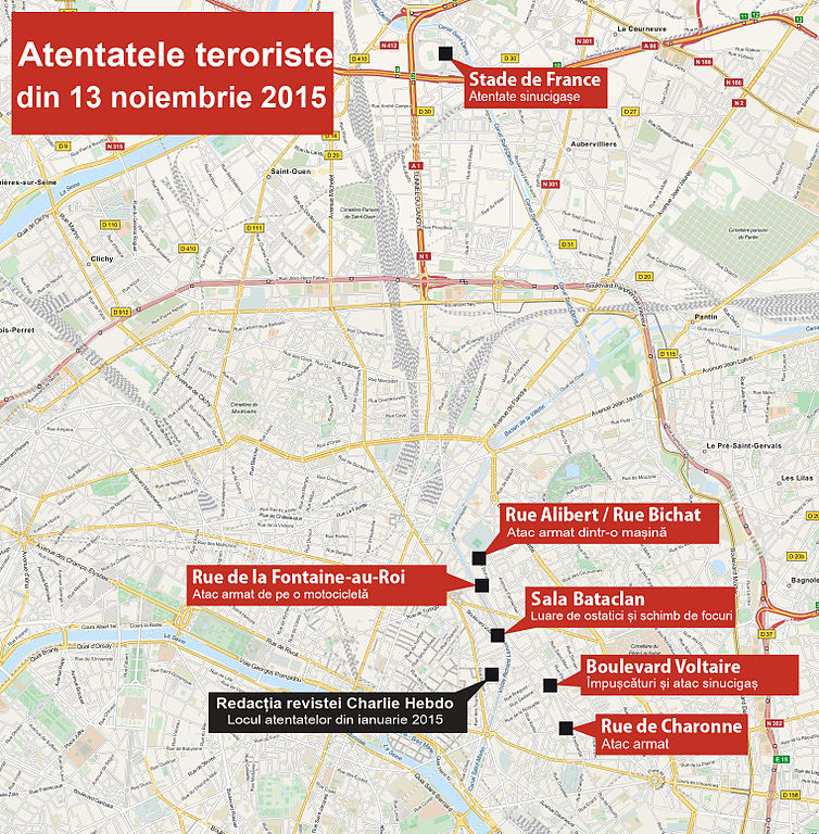
Deutsch: Karte der Terroranschläge vom 13. November 2015 in Paris. Rumänische Version
English: Map of the 2015 Paris attacks. Version in Romanian
Français : Plan des attentats du 13 novembre 2015 en Île-de-France |
|||
| Date | see file history | |||
| Source |
Own work, using OpenStreetMap data for the background based on information from the French Wikipedia article Attentats du 13 novembre 2015 en Île-de-France. |
|||
| Author | original map: Maximilian Dörrbecker (Chumwa), translation: Dan Mihai Pitea | |||
| Permission (Reusing this file) |
This file is licensed under the Creative Commons Attribution-Share Alike 2.0 Generic license.
|
|||
| Other versions |
|


File history
Click on a date/time to view the file as it appeared at that time.
| Date/Time | Thumbnail | Dimensions | User | Comment | |
|---|---|---|---|---|---|
| current | 16:17, 14 November 2015 | | 1,524 × 1,553 (1.14 MB) | Dan Mihai Pitea (talk | contribs) | Theater-> Sala |
| 15:47, 14 November 2015 |  | 1,524 × 1,553 (1.14 MB) | Dan Mihai Pitea (talk | contribs) | corrections | |
| 12:20, 14 November 2015 |  | 1,524 × 1,553 (1.13 MB) | Dan Mihai Pitea (talk | contribs) | User created page with UploadWizard |
You cannot overwrite this file.
File usage on Commons
The following 2 pages use this file:
File usage on other wikis
The following other wikis use this file:
- Usage on ro.wikipedia.org