File:Karte saarbruecken in deutschland.png
No higher resolution available.
Karte_saarbruecken_in_deutschland.png (188 × 235 pixels, file size: 5 KB, MIME type: image/png)
Captions
Captions
Add a one-line explanation of what this file represents
Summary edit
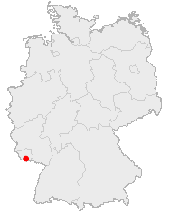
English: Location of Saabruecken in Germany
Lëtzebuergesch: Lag vu Saarbrécken an Däitschland
Zusammenfassung edit
Lage von Saarbrücken in Deutschland
Licensing edit
This image was generated with OpenGeoDB. The information there is placed in the public domain, images generated from OpenGeoDB are derivative works without passing the threshold of creativity, they are therefore also public domain.
| This work is ineligible for copyright and therefore in the public domain because it consists entirely of information that is common property and contains no original authorship. |
File history
Click on a date/time to view the file as it appeared at that time.
| Date/Time | Thumbnail | Dimensions | User | Comment | |
|---|---|---|---|---|---|
| current | 16:18, 25 June 2006 | | 188 × 235 (5 KB) | Yassen~commonswiki (talk | contribs) | english:Location of Saabrucken in Germany<br> deutsch:Lage von Saarbrücken in Deutschland<br> {{GFDL-OpenGeoDB}} Category:Locator_maps_of_cities_in_Germany |
You cannot overwrite this file.
File usage on Commons
The following page uses this file:
File usage on other wikis
The following other wikis use this file:
- Usage on af.wikipedia.org
- Usage on azb.wikipedia.org
- Usage on de.wikipedia.org
- Usage on de.wikinews.org
- Usage on fa.wikipedia.org
- Usage on fy.wikipedia.org
- Usage on io.wikipedia.org
- Usage on is.wikipedia.org
- Usage on ja.wikipedia.org
- Usage on la.wiktionary.org
- Usage on lmo.wikipedia.org
- Usage on pl.wikivoyage.org
- Usage on pms.wikipedia.org
- Usage on pnb.wikipedia.org
- Usage on ps.wikipedia.org
- Usage on sq.wikipedia.org
- Usage on uk.wikipedia.org
- Usage on zh-yue.wikipedia.org