File:Kastelruth Radlmoos.jpg

Size of this preview: 800 × 350 pixels. Other resolutions: 320 × 140 pixels | 640 × 280 pixels | 1,024 × 448 pixels | 1,280 × 560 pixels | 2,560 × 1,119 pixels | 8,133 × 3,556 pixels.
Original file (8,133 × 3,556 pixels, file size: 23.58 MB, MIME type: image/jpeg)
Captions
Captions
Add a one-line explanation of what this file represents
Summary
edit| Description |
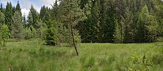
English: Wetland Radlmoos in Kastelruth.
Deutsch: Radlmoos in Kastelruth - Breites Tälchen mit vermoortem Gebiet in Muldenlage. Der nördlich gelegene, künstlich angelegte Weiher (mit Dämmen) trennt ein kleines Gebiet ab. Der floristisch interessanteste Teil dieses Moores befindet sich im Südwesten und wird von Schnabelsegge (Carex rostrata), Rasenschmiele (Deschampsia caespitosa) und Sumpfveilchen (Viola palustris) beherrscht. Gegen den Hang und die Straße hin schließt sich ein stark vom Vieh zertretener Bereich mit einer Reihe von Anmoorarten an. Hier dominieren Sumpfkratzdistel (Cirsium palustre), Binsen (Juncus effusus und J. conglomeratus) und Rasenschmiele (Deschampsia caespitosa). Die Wasserversorgung kann als gut bezeichnet werden. Im südwestlichen Teil ist das Moor sehr tief. Es könnte sich an dieser Stelle um einen verlandeten See handeln.
Italiano: Palude Radlmoos a Castelrotto - Larga valletta con zona paludosa in una conca. Il laghetto artificiale posto a nord (arginato) divide una piccola porzione di terreno. La parte migliore dal punto di vista floristico di questa torbiera si trova a sudovest ed é dominata da Carice rignofia (Carex rostrata), Migliarino maggiore (Deschampsia caespitosa) e Viola palustre (Viola palustris). Verso il pendio e la strada confina con una zona molto calpestata dal bestiame con diverse specie tipiche di torbiera. Qui dominano Cardo di palude (Cirsium palustre), Giunchi (Juncus effusus e J. conglomeratus) e Migliarino maggiore (Deschampsia caespitosa). L'approvvigionamento d'acqua é buono. Nella parte sudoccidentale la palude é molto profonda. Si protrebbe trattare, in questa zona, di un lago interrato.
|
||||||
| Date | |||||||
| Source | Own work | ||||||
| Author |
|
||||||
| Permission (Reusing this file) |
Own work, attribution required (Multi-license with GFDL and Creative Commons CC-BY 2.5). Capture: Photo by Wolfgang Moroder |

| Object location | | View this and other nearby images on: OpenStreetMap |
|---|

|
NOTE: This image is a panorama of 3 photos consisting of multiple frames that were merged or stitched in software. As a result, this image necessarily underwent some form of digital manipulation. These manipulations may include blending, blurring, cloning, and colour and perspective adjustments. As a result of these adjustments, the image content may be slightly different from reality at the points where multiple images were combined. This manipulation is often required due to lens, perspective, and parallax distortions.
|
Licensing
edit
I, the copyright holder of this work, hereby publish it under the following license:
This file is licensed under the Creative Commons Attribution-Share Alike 3.0 Unported license.
- You are free:
- to share – to copy, distribute and transmit the work
- to remix – to adapt the work
- Under the following conditions:
- attribution – You must give appropriate credit, provide a link to the license, and indicate if changes were made. You may do so in any reasonable manner, but not in any way that suggests the licensor endorses you or your use.
- share alike – If you remix, transform, or build upon the material, you must distribute your contributions under the same or compatible license as the original.
}}
This image has been assessed using the Quality image guidelines and is considered a Quality image.
|
File history
Click on a date/time to view the file as it appeared at that time.
| Date/Time | Thumbnail | Dimensions | User | Comment | |
|---|---|---|---|---|---|
| current | 10:03, 20 June 2017 | | 8,133 × 3,556 (23.58 MB) | Moroder (talk | contribs) | fixed stitching error |
| 17:09, 16 June 2017 |  | 8,133 × 3,556 (23.55 MB) | Moroder (talk | contribs) | {{Information{{Largeimage}} == {{int:filedesc}} == {{Information |Description= {{en|1=Wetland Radlmoos in {{w|Kastelruth}}.}} {{de|1=Radlmoos in {{wd|Kastelruth}} - Breites Tälchen mit vermoortem Gebiet in Muldenlage. Der nördlich gelegene, künstlic... |
You cannot overwrite this file.
File usage on Commons
The following 5 pages use this file:
File usage on other wikis
The following other wikis use this file:
- Usage on de.wikipedia.org
- Usage on lld.wikipedia.org