File:Katrina QST 2005240 lrg.jpg

Size of this preview: 548 × 599 pixels. Other resolutions: 219 × 240 pixels | 439 × 480 pixels | 702 × 768 pixels | 937 × 1,024 pixels | 1,500 × 1,640 pixels.
Original file (1,500 × 1,640 pixels, file size: 1.7 MB, MIME type: image/jpeg)
Captions
Captions
Add a one-line explanation of what this file represents
Summary edit
| Description |
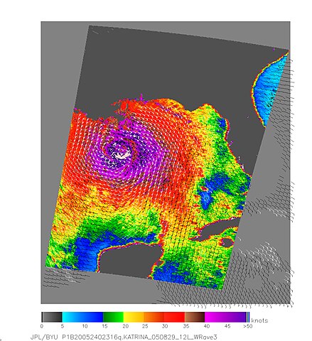
English: Hurricane Katrina exploded into a Category 5 storm on August 28 as it moved north through the Gulf of Mexico towards the United States. It is one of the most powerful storms on record for the Atlantic Basin.
Nearly the whole of the Gulf of Mexico was churning with the powerful winds and rains of Hurricane Katrina on August 28, 2005, when NASA’s QuikSCAT satellite captured this image. The image depicts relative wind speeds swirling around the calm center of the storm. The highest wind speeds, shown in shades of purple, circle a well-defined eye, with gradually weakening winds radiating outward. The barbs reveal wind direction, and the white barbs show heavy rainfall. At the time this image was taken, the National Hurricane Center reported that Katrina had winds of 160 miles per hour (257 kilometers per hour or 140 knots) with stronger gusts, and it was moving north-northwest at about 10 mph (16 km/hr). The storm weakened slightly before coming ashore, but was still a powerfully destructive storm. |
| Date | |
| Source | http://visibleearth.nasa.gov/view_rec.php?id=20206 |
| Author | NASA / JPL |
| Permission (Reusing this file) |
Public Domain |
Licensing edit
| This file is in the public domain in the United States because it was solely created by NASA. NASA copyright policy states that "NASA material is not protected by copyright unless noted". (See Template:PD-USGov, NASA copyright policy page or JPL Image Use Policy.) | ||
 |
Warnings:
|
File history
Click on a date/time to view the file as it appeared at that time.
| Date/Time | Thumbnail | Dimensions | User | Comment | |
|---|---|---|---|---|---|
| current | 16:30, 25 November 2009 | | 1,500 × 1,640 (1.7 MB) | Cyclonebiskit (talk | contribs) | {{Information |Description={{en|1=Hurricane Katrina exploded into a Category 5 storm on August 28 as it moved north through the Gulf of Mexico towards the United States. It is one of the most powerful storms on record for the Atlantic Basin. Nearly the |
You cannot overwrite this file.
File usage on Commons
There are no pages that use this file.
File usage on other wikis
The following other wikis use this file: