File:Katyn massacres 1940 map-de.svg

Size of this PNG preview of this SVG file: 765 × 599 pixels. Other resolutions: 306 × 240 pixels | 613 × 480 pixels | 980 × 768 pixels | 1,280 × 1,003 pixels | 2,560 × 2,006 pixels | 1,053 × 825 pixels.
Original file (SVG file, nominally 1,053 × 825 pixels, file size: 191 KB)
Captions
Captions
Add a one-line explanation of what this file represents
| Description |
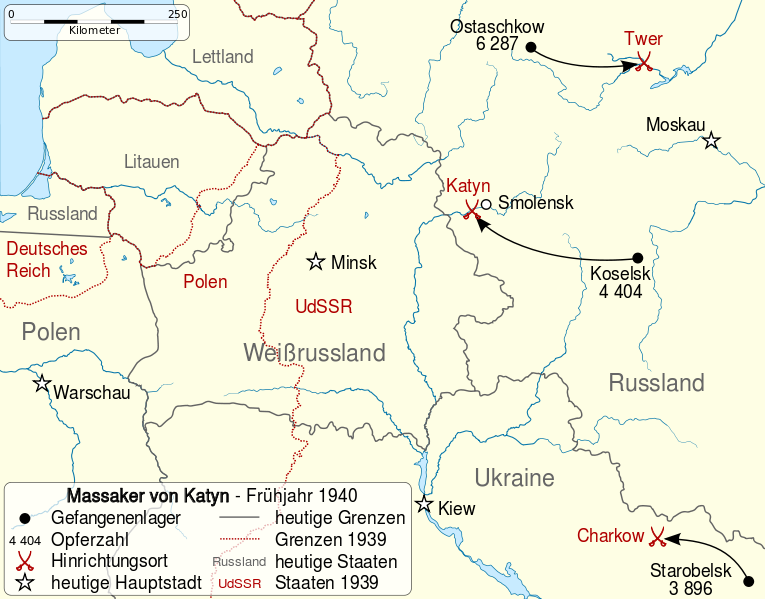
Deutsch: Karte der Massaker von Katyn und anderer Massaker im Frühjahr 1940. English: Map of the Katyn massacres (in the widest sense) during 1940 spring. Français : Carte des massacres de Katyń (au sens large) durant le printemps 1940. |
| Date | (UTC) |
| Source | |
| Author |
|
| Other versions |
|

| This is a retouched picture, which means that it has been digitally altered from its original version. Modifications: translation. The original can be viewed here: Katyn massacres 1940 map-fr.svg:
|
I, the copyright holder of this work, hereby publish it under the following licenses:
This file is licensed under the Creative Commons Attribution-Share Alike 3.0 Unported, 2.5 Generic, 2.0 Generic and 1.0 Generic license.
- You are free:
- to share – to copy, distribute and transmit the work
- to remix – to adapt the work
- Under the following conditions:
- attribution – You must give appropriate credit, provide a link to the license, and indicate if changes were made. You may do so in any reasonable manner, but not in any way that suggests the licensor endorses you or your use.
- share alike – If you remix, transform, or build upon the material, you must distribute your contributions under the same or compatible license as the original.

|
Permission is granted to copy, distribute and/or modify this document under the terms of the GNU Free Documentation License, Version 1.2 or any later version published by the Free Software Foundation; with no Invariant Sections, no Front-Cover Texts, and no Back-Cover Texts. A copy of the license is included in the section entitled GNU Free Documentation License. |
You may select the license of your choice.
Original upload log edit
This image is a derivative work of the following images:
- File:Katyn_massacres_1940_map-fr.svg licensed with Cc-by-sa-3.0,2.5,2.0,1.0, GFDL
- 2010-04-26T14:06:57Z Sémhur 1053x825 (199071 Bytes) {{Information |Description={{Multilingual description |en= Map of the [[:en:Katyn massacre|Katyn massacres]] (in the widest sense) during 1940 spring. |fr= Carte des [[:fr:Massacre de Katyń|massacres de Katyń]] (au sens lar
Uploaded with derivativeFX
File history
Click on a date/time to view the file as it appeared at that time.
| Date/Time | Thumbnail | Dimensions | User | Comment | |
|---|---|---|---|---|---|
| current | 19:32, 7 October 2011 | | 1,053 × 825 (191 KB) | NordNordWest (talk | contribs) | {{Information |Description={{Multilingual description |de = Karte der Massaker von Katyn und anderer Massaker im Frühjahr 1940. |en= Map of the Katyn massacres (in the widest sense) during 1940 spring. |f |
You cannot overwrite this file.
File usage on Commons
The following page uses this file:
File usage on other wikis
The following other wikis use this file:
- Usage on ga.wikipedia.org