File:Kelly's and Bass Islands showing the harbors of refuge in their vicinity being an extract from the survey of the west end of Lake Erie made under the direction of the Bureau of Topographical LOC 2012593349.jpg

Size of this preview: 737 × 600 pixels. Other resolutions: 295 × 240 pixels | 590 × 480 pixels | 944 × 768 pixels | 1,258 × 1,024 pixels | 2,516 × 2,048 pixels | 7,648 × 6,225 pixels.
Original file (7,648 × 6,225 pixels, file size: 6.24 MB, MIME type: image/jpeg)
Captions
Captions
Add a one-line explanation of what this file represents
Summary
edit| Description |
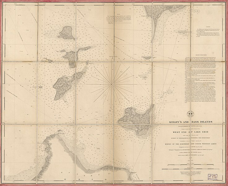
English: Relief shown by gradient tints and soundings. "At head of title: Survey of the Lakes T.E. 1852." LC copy: Signed on verso: Millard Fillmore. LC copy: One of the first three charts published by the Lake Survey. For others, see Fillmore no. 117 and 118. Available also through the Library of Congress Web site as a raster image. |
||
| Title | Kelly's and Bass Islands showing the harbors of refuge in their vicinity being an extract from the survey of the west end of Lake Erie made under the direction of the Bureau of Topographical Engineers, War Department : in obedience to Acts of Congress requiring the Survey of the northern and north western lakes. | ||
| Shelf ID | G4082.K4 1849 .U5 | ||
| Date | |||
| Source | https://www.loc.gov/item/2012593349/ | ||
| Author | United States. Topographical Bureau | ||
| Permission (Reusing this file) |
|
||
| Other versions |
|
||
| Location | Kelleys Island · Kelleys Island. · United States · Bass Islands. · Bass Islands · Ohio | ||
| Part of | American Memory · General Maps · Catalog · Geography And Map Division | ||
| Subject | Kelleys Island · Bass Islands · Bass Islands (Ohio) · United States · Maps · Kelleys Island (Ohio) · Ohio |

Licensing
edit
|
This is a faithful photographic reproduction of a two-dimensional, public domain work of art. The work of art itself is in the public domain for the following reason:
The official position taken by the Wikimedia Foundation is that "faithful reproductions of two-dimensional public domain works of art are public domain".
This photographic reproduction is therefore also considered to be in the public domain in the United States. In other jurisdictions, re-use of this content may be restricted; see Reuse of PD-Art photographs for details. | ||||
File history
Click on a date/time to view the file as it appeared at that time.
| Date/Time | Thumbnail | Dimensions | User | Comment | |
|---|---|---|---|---|---|
| current | 00:25, 3 June 2018 | | 7,648 × 6,225 (6.24 MB) | Fæ (talk | contribs) | LOC Maps https://www.loc.gov/item/2012593349/ #18441 |
You cannot overwrite this file.
File usage on Commons
The following page uses this file: