File:Keltenwall131011 38luftbild.jpg

Size of this preview: 800 × 401 pixels. Other resolutions: 320 × 160 pixels | 640 × 320 pixels | 1,024 × 513 pixels | 1,280 × 641 pixels | 2,930 × 1,467 pixels.
Original file (2,930 × 1,467 pixels, file size: 796 KB, MIME type: image/jpeg)
Captions
Captions
Add a one-line explanation of what this file represents
Summary
edit
| Description |
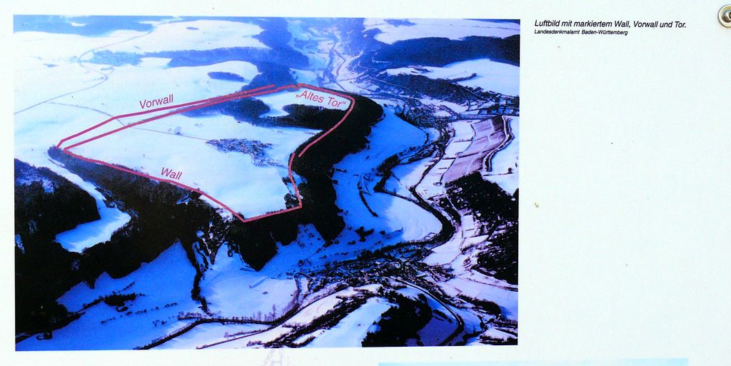
Deutsch: Luftbild der keltischen Befestigungsanlage Finsterlohr/Burgstall |
| Date | |
| Source |
Own work Original text: selbst fotografiert von Arnold Plesse |
| Author | Infortafel am archaeologischen Lehrpfad in Finsterlohr/Burgstall |
Licensing
edit
This file is licensed under the Creative Commons Attribution-Share Alike 3.0 Germany license.
- You are free:
- to share – to copy, distribute and transmit the work
- to remix – to adapt the work
- Under the following conditions:
- attribution – You must give appropriate credit, provide a link to the license, and indicate if changes were made. You may do so in any reasonable manner, but not in any way that suggests the licensor endorses you or your use.
- share alike – If you remix, transform, or build upon the material, you must distribute your contributions under the same or compatible license as the original.

|
The photographical reproduction of this work is covered under the article § 59 of the German copyright law, which states that "It shall be permissible to reproduce, by painting, drawing, photography or cinematography, works which are permanently located on public ways, streets or places and to distribute and publicly communicate such copies. For works of architecture, this provision shall be applicable only to the external appearance."
As with all other “limits of copyright by legally permitted uses”, no changes to the actual work are permitted under § 62 of the German copyright law (UrhG). See Commons:Copyright rules by territory/Germany#Freedom of panorama for more information.
|
Original upload log
edit
Transferred from de.wikipedia to Commons by Wdwdbot using script bot_filetrans.pl (r39M).
The original description page was here. All following user names refer to de.wikipedia.
- 2011-11-23 21:34:07 Agp (815406 Bytes) {{Information |Beschreibung = Luftbild der keltischen Befestigungsanlage Finsterlohr/Burgstall |Quelle = selbst fotografiert von Arnold Plesse |Urheber = Infortafel am archaeologischen Lehrpfad in Finsterlohr/Burgstall |Datum

|
The categories of this image need checking. You can do so here.
|
File history
Click on a date/time to view the file as it appeared at that time.
| Date/Time | Thumbnail | Dimensions | User | Comment | |
|---|---|---|---|---|---|
| current | 15:07, 17 October 2015 | | 2,930 × 1,467 (796 KB) | Wdwdbot (talk | contribs) | Bot Move: Original uploader of this revision (#1) was Agp at de.wikipedia |
You cannot overwrite this file.
File usage on Commons
The following 3 pages use this file:
File usage on other wikis
The following other wikis use this file:
- Usage on de.wikipedia.org
- Oppidum Finsterlohr
- Benutzer:Agp/Meine Bilder
- Benutzer:Triplec85/BW-TBB-Creglingen
- Benutzer:Triplec85/Burgstall
- Benutzer:Triplec85/BW-TBB-Wohnplatz
- Benutzer:Triplec85/BW-TBB-Ortsteil
- Benutzer:Triplec85/BW-TBB-Siedlung
- Liste der Burgen, Schlösser, Adelssitze und wehrhaften Stätten im Main-Tauber-Kreis
- Usage on www.wikidata.org