File:Kenya Tanzania Uganda.jpg

Size of this preview: 800 × 566 pixels. Other resolutions: 320 × 226 pixels | 640 × 453 pixels | 1,024 × 725 pixels | 1,280 × 906 pixels | 2,560 × 1,812 pixels | 2,952 × 2,089 pixels.
Original file (2,952 × 2,089 pixels, file size: 6.16 MB, MIME type: image/jpeg)
Captions
Captions
Add a one-line explanation of what this file represents
Summary edit
| Kenya, Tanzania, Uganda | |
|---|---|
| Photographer |
Envisat satellite |
| Title |
Kenya, Tanzania, Uganda |
| Description |
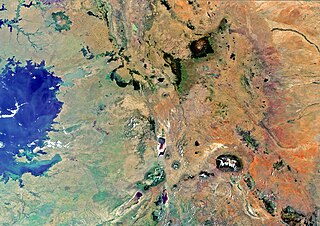
English: The border region of southern Kenya and northern Tanzania – with a small portion of south eastern Uganda – is pictured in this image, acquired by Envisat’s MERIS instrument on 4 January 2012.
In the lower-right portion of the image, we can see the snows of Kilimanjaro, Africa’s highest mountain at 5895 m above sea level. North of Mount Kilimanjaro is Mount Kenya, the second-highest mountain in Africa. The area pictured is part of the East African Rift – an area where two tectonic plates are moving apart from one another – making this home to a number of both active and dormant volcanoes. |
| Depicted place | Kilmanjaro |
| Date | 4 January 2012 |
| Collection | European Space Agency |
| Accession number |
272601 |
| Credit line | ESA |
| Source | http://www.esa.int/spaceinimages/Images/2012/05/Kenya_Tanzania_Uganda |
Licensing edit
This file is licensed under the Creative Commons Attribution-ShareAlike 3.0 IGO license.
- You are free:
- to share – to copy, distribute and transmit the work
- to remix – to adapt the work
- Under the following conditions:
- attribution – You must give appropriate credit, provide a link to the license, and indicate if changes were made. You may do so in any reasonable manner, but not in any way that suggests the licensor endorses you or your use.
- share alike – If you remix, transform, or build upon the material, you must distribute your contributions under the same or compatible license as the original.
File history
Click on a date/time to view the file as it appeared at that time.
| Date/Time | Thumbnail | Dimensions | User | Comment | |
|---|---|---|---|---|---|
| current | 11:24, 22 February 2017 | | 2,952 × 2,089 (6.16 MB) | Revent (talk | contribs) | =={{int:filedesc}}== {{Photograph |photographer = Envisat satellite |title = Kenya, Tanzania, Uganda |description = {{en|The border region of southern Kenya and northern Tanzania – with a small portion of south eastern Ug... |
You cannot overwrite this file.
File usage on Commons
The following 4 pages use this file: