File:Kerala-administrative-divisions-map-en.svg

Size of this PNG preview of this SVG file: 540 × 600 pixels. Other resolutions: 216 × 240 pixels | 432 × 480 pixels | 691 × 768 pixels | 922 × 1,024 pixels | 1,843 × 2,048 pixels | 2,700 × 3,000 pixels.
Original file (SVG file, nominally 2,700 × 3,000 pixels, file size: 395 KB)
Captions
Captions
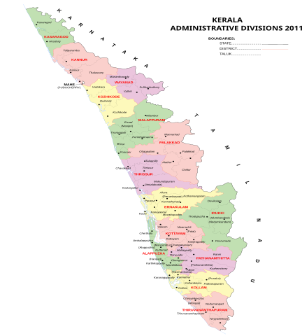
Taluks in Kerala administrative divisions 2011
Summary edit
| Description |
English: Kerala administrative divisions 2011, svg version, English |
| Date | (UTC) |
| Source | Own work |
| Author | Rajeshodayanchal |
Licensing edit
I, the copyright holder of this work, hereby publish it under the following license:
This file is licensed under the Creative Commons Attribution-Share Alike 3.0 Unported license.
- You are free:
- to share – to copy, distribute and transmit the work
- to remix – to adapt the work
- Under the following conditions:
- attribution – You must give appropriate credit, provide a link to the license, and indicate if changes were made. You may do so in any reasonable manner, but not in any way that suggests the licensor endorses you or your use.
- share alike – If you remix, transform, or build upon the material, you must distribute your contributions under the same or compatible license as the original.
File history
Click on a date/time to view the file as it appeared at that time.
| Date/Time | Thumbnail | Dimensions | User | Comment | |
|---|---|---|---|---|---|
| current | 06:03, 11 May 2011 | | 2,700 × 3,000 (395 KB) | Rajeshodayanchal (talk | contribs) | Removed hidden layers from the file |
| 06:38, 10 May 2011 |  | 2,700 × 3,000 (458 KB) | Rajeshodayanchal (talk | contribs) | Some small changes | |
| 08:56, 9 May 2011 |  | 2,700 × 3,000 (403 KB) | Rajeshodayanchal (talk | contribs) | {{Information |Description ={{en|1=Kerala administrative divisions 2011, svg version, English}} |Source ={{own}} |Author =Rajeshodayanchal |Date =~~~~~ |Permission = |other_versions = }} [[Catego |
You cannot overwrite this file.
File usage on Commons
The following page uses this file:
File usage on other wikis
The following other wikis use this file:
- Usage on fr.wikipedia.org